ZCZC MIATWOEP ALL
TTAA00 KNHC DDHHMM
Tropical Weather Outlook
NWS National Hurricane Center Miami FL
500 AM PDT Thu Sep 12 2019
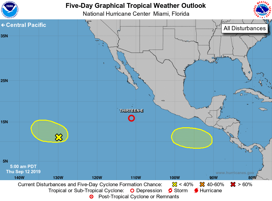
For the eastern North Pacific...east of 140 degrees west longitude:
1. Showers and thunderstorms have become more concentrated and better
organized this morning around an area of low pressure located about
500 miles south of the southern tip of the Baja California
peninsula, and a tropical depression appears to be forming. If this
trend continues, advisories will be initiated later this morning or
afternoon while the system moves west-northwestward at about 10 mph.
For additional information on this system, please refer to High Seas
Forecasts issued by the National Weather Service.
* Formation chance through 48 hours...high...near 100 percent.
* Formation chance through 5 days...high...near 100 percent.
2. A tropical wave located about 1500 miles southwest of the southern
tip of the Baja California peninsula continues to produce
disorganized showers and thunderstorms. Some slow development of
this disturbance is possible during the next few days while the
system moves slowly westward at 5 to 10 mph.
* Formation chance through 48 hours...low...20 percent.
* Formation chance through 5 days...low...30 percent.
3. An area of low pressure is expected to form west of the coast of
Central America over the weekend. Development of this system is
possible early next week while it moves westward well south of the
southern coast of Mexico.
* Formation chance through 48 hours...low...near 0 percent.
* Formation chance through 5 days...low...30 percent.
High Seas Forecasts issued by the National Weather Service can be
found under AWIPS header NFDHSFEPI, WMO header FZPN02 KWBC, and on
the web at ocean.weather.gov/shtml/NFDHSFEPI.php
Forecaster Latto