ZCZC MIATWOAT ALL
TTAA00 KNHC DDHHMM
Tropical Weather Outlook
NWS National Hurricane Center Miami FL
800 AM EDT Thu Sep 5 2019
For the North Atlantic...Caribbean Sea and the Gulf of Mexico:
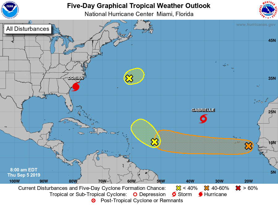
The National Hurricane Center is issuing advisories on Hurricane
Dorian, located a little less than 100 miles south-southeast of
Charleston, South Carolina, and on Tropical Storm Gabrielle, located
several hundred miles west-northwest of the Cabo Verde Islands.
1. A small area of low pressure located a few hundred miles northeast
of Bermuda is producing limited showers and thunderstorms, well to
the southeast of the center. Significant development of this system
is not anticipated while it moves northeastward across the central
north Atlantic due to unfavorable upper-level winds.
* Formation chance through 48 hours...low...30 percent.
* Formation chance through 5 days...low...30 percent.
2. A trough of low pressure located about 500 miles east of the Leeward
Islands is producing a large but disorganized area of showers and
thunderstorms. Only slow development of this disturbance, if any, is
expected during the next couple of days while it moves slowly
northwestward.
* Formation chance through 48 hours...low...10 percent.
* Formation chance through 5 days...low...10 percent.
3. A broad area of low pressure associated with a tropical wave located
about halfway between the coast of Africa and the Cabo Verde Islands
is producing disorganized showers and thunderstorms. Gradual
development of this system is possible and a tropical depression
could form while it moves westward across the tropical Atlantic
Ocean through early next week.
* Formation chance through 48 hours...low...10 percent.
* Formation chance through 5 days...medium...50 percent.
Forecaster Zelinsky