ZCZC MIATWOAT ALL
TTAA00 KNHC DDHHMM
Tropical Weather Outlook
NWS National Hurricane Center Miami FL
800 PM EDT Fri Aug 23 2019
For the North Atlantic...Caribbean Sea and the Gulf of Mexico:
The National Hurricane Center is issuing advisories on Tropical
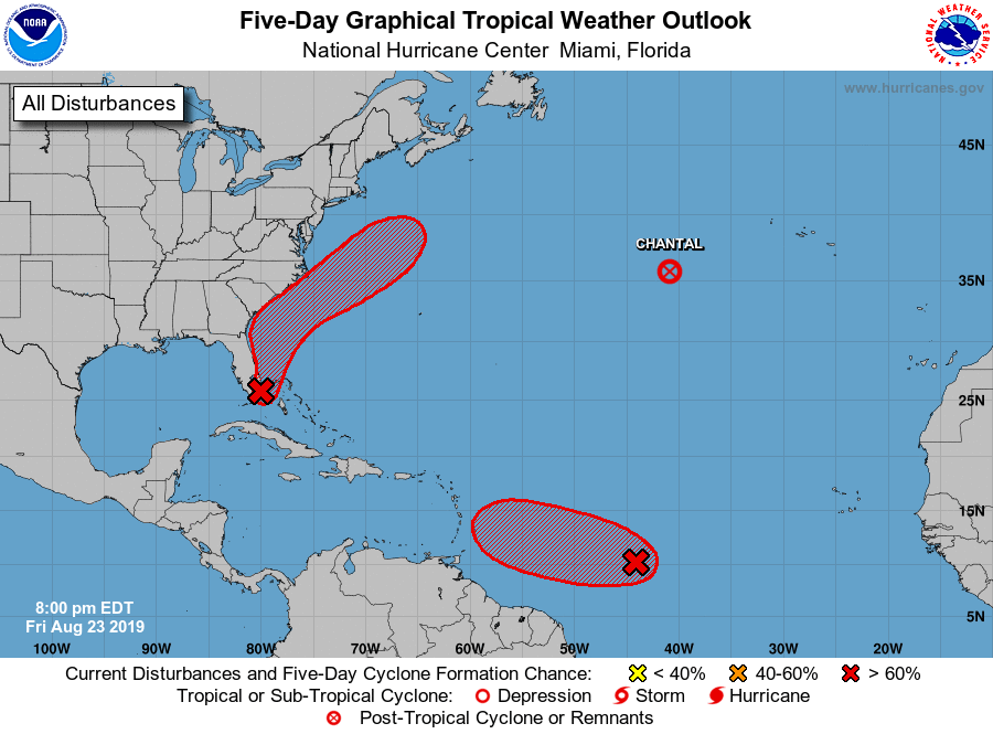
Depression Chantal, located several hundred miles west of the
Azores.
1. A broad area of low pressure located near the coast of southeastern
Florida continues to produce a large area of showers and
thunderstorms that extend eastward over the northern Bahamas and the
adjacent western Atlantic waters. The system has changed little in
organization since this afternoon, but environmental conditions are
expected to be conducive for gradual development, and a tropical
depression is likely to form over the weekend. The low is forecast
to move generally northwestward near or over southeastern Florida
through tonight, and then move northward to northeastward over the
Atlantic near the east coast of central Florida on Saturday. After
that, the system is expected to move northeastward offshore of the
southeastern United States coast. Regardless of development, locally
heavy rains are possible over the northwestern Bahamas and the
southern and central Florida peninsula through the weekend.
Interests in the northwestern Bahamas, the Florida peninsula, and
the southeast coast of the United States should monitor the progress
of this system. An Air Force Reserve Hurricane Hunter aircraft is
scheduled to investigate the system on Saturday, if necessary.
* Formation chance through 48 hours...high...70 percent.
* Formation chance through 5 days...high...90 percent.
2. Satellite imagery suggests that the circulation associated with an
area of low pressure located about 1100 miles east-southeast of
the Windward Islands has become better defined, but the thunderstorm
activity is limited at this time. Environmental conditions appear
conducive for additional development, and a tropical depression is
likely to form over the weekend or early next week while it moves
generally westward to west-northwestward near 15 mph.
* Formation chance through 48 hours...medium...60 percent.
* Formation chance through 5 days...high...70 percent.
Forecaster Brown