ZCZC MIATWOAT ALL
TTAA00 KNHC DDHHMM
Tropical Weather Outlook
NWS National Hurricane Center Miami FL
800 AM EDT Fri Aug 23 2019
For the North Atlantic...Caribbean Sea and the Gulf of Mexico:
The National Hurricane Center is issuing advisories on Tropical
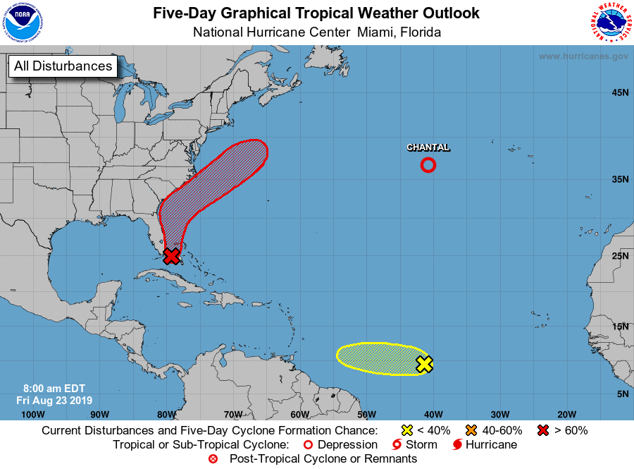
Depression Chantal, located about 765 miles west of the Azores.
1. Surface and radar data indicate that a weak area of low pressure is
located just east of the upper Florida Keys and the southeastern
coast of the Florida peninsula. This system is producing a large
area of disorganized cloudiness and showers that extends primarily
northeast of the center over the northwestern Bahamas and the
adjacent Atlantic Ocean. The low is forecast to move near or over
the Florida peninsula through tonight, which should limit
development during that time. Environmental conditions appear
conducive for development once the system moves northeastward back
over the Atlantic waters on Saturday. A tropical depression is
likely to form this weekend or early next week while the low moves
from near the coast of east-central Florida to offshore of the
southeastern United States coast. Regardless of development,
locally heavy rains are possible over the northwestern Bahamas and
southern and central Florida through the weekend.
* Formation chance through 48 hours...medium...40 percent.
* Formation chance through 5 days...high...70 percent.
2. Showers and thunderstorms have increased since yesterday in
association with a tropical wave located about 1400 miles
east-southeast of the Windward Islands. Additional slow development
of this system is possible during the next few days as it moves
generally westward at about 15 mph.
* Formation chance through 48 hours...low...10 percent.
* Formation chance through 5 days...low...20 percent.
Forecaster Beven