ZCZC MIATWOEP ALL
TTAA00 KNHC DDHHMM
Tropical Weather Outlook
NWS National Hurricane Center Miami FL
1100 AM PDT Thu Aug 8 2019
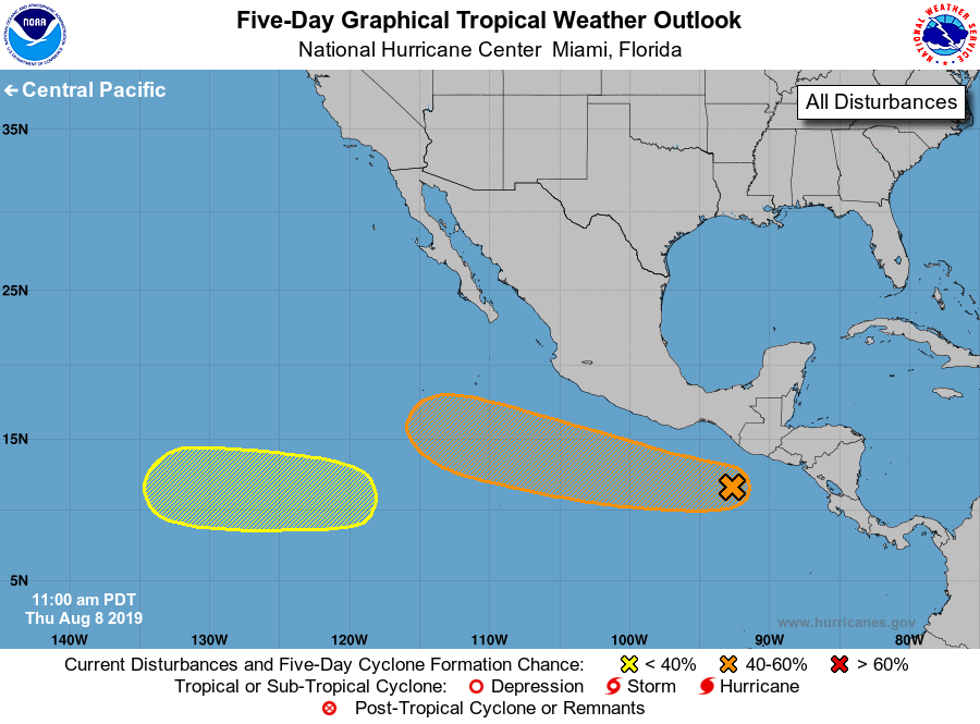
For the eastern North Pacific...east of 140 degrees west longitude:
1. An area of cloudiness and thunderstorms has developed along and to
the south of the coasts of El Salvador and Nicaragua. A low pressure
area is forecast to form within this area of disturbed weather a few
hundred miles south or southwest of the southern coast of Mexico by
this weekend, and environmental conditions are expected to be
somewhat conducive for the formation of a tropical depression by
early next week while the system moves west-northwestward at 10 to
15 mph, offshore of the southwestern coast of Mexico. Some
thunderstorm activity is expected to move onshore the coasts of
El Salvador and Nicaragua tonight and Friday, producing locally
heavy rainfall, especially in mountainous areas. These rains are
forecast to gradually spread westward along the coast of
southeastern Mexico over the weekend.
* Formation chance through 48 hours...low...10 percent.
* Formation chance through 5 days...medium...60 percent.
2. An area of low pressure is forecast to develop several hundred miles
southwest of the southern tip of the Baja California peninsula by
early next week. Environmental conditions are expected to gradually
become more conducive for development through the middle of next
week while the system moves generally westward at 10 to 15 mph.
* Formation chance through 48 hours...low...near 0 percent.
* Formation chance through 5 days...low...20 percent.
Forecaster Stewart