ZCZC MIATWOEP ALL
TTAA00 KNHC DDHHMM
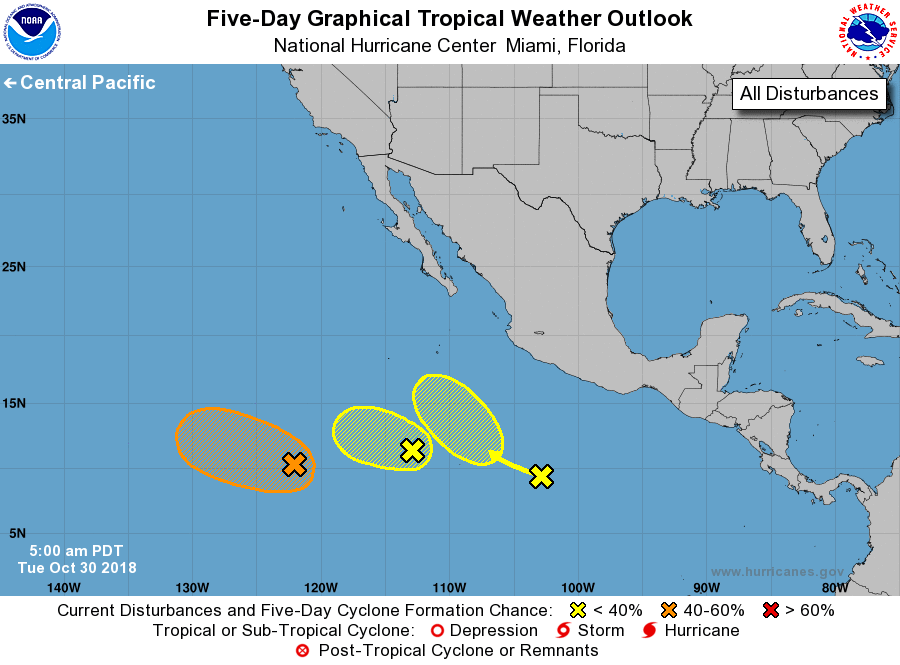
Tropical Weather Outlook
NWS National Hurricane Center Miami FL
500 AM PDT Tue Oct 30 2018
For the eastern North Pacific...east of 140 degrees west longitude:
1. Showers and thunderstorms associated with a weak area of low
pressure located about 800 miles south-southwest of the southern tip
of the Baja California peninsula remain disorganized. Significant
development of this system is not expected while it moves westward
or west-northwestward at about 10 mph.
* Formation chance through 48 hours...low...10 percent.
* Formation chance through 5 days...low...10 percent.
2. An elongated area of low pressure located about 1200 miles southwest
of the southern tip of the Baja California peninsula is producing
disorganized showers and thunderstorms. Some slow development of
this system is possible over the next few days while the disturbance
moves toward the west or west-northwest at 5 to 10 mph.
* Formation chance through 48 hours...low...30 percent.
* Formation chance through 5 days...medium...40 percent.
3. A third area of disturbed weather is located several hundred miles
south-southwest of Acapulco, Mexico. Environmental conditions
appear conducive for gradual development of this system through the
weekend while it moves west-northwestward at about 10 mph.
* Formation chance through 48 hours...low...near 0 percent.
* Formation chance through 5 days...low...20 percent.
Forecaster Berg