ZCZC MIATWOAT ALL
TTAA00 KNHC DDHHMM
Tropical Weather Outlook
NWS National Hurricane Center Miami FL
200 AM EDT Fri Sep 21 2018
For the North Atlantic...Caribbean Sea and the Gulf of Mexico:
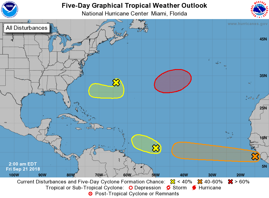
1. A tropical wave located more than 700 miles southeast of the Cabo
Verde Islands. Some gradual development of this system is possible
during the next several days as the disturbance moves westward at
15 to 20 mph across the low latitudes of the eastern and central
tropical Atlantic Ocean.
* Formation chance through 48 hours...low...10 percent.
* Formation chance through 5 days...medium...50 percent.
2. A small but concentrated area of showers and thunderstorms
associated with a tropical wave is located about 650 miles east of
the Windward Islands. The combination of dry mid-level air and
strong upper-level winds is expected to hinder any development of
this disturbance while it moves westward to west-northwestward at
around 10 mph.
* Formation chance through 48 hours...low...10 percent.
* Formation chance through 5 days...low...10 percent.
3. A non-tropical area of low pressure located less than 100 miles
northeast of Bermuda, is moving southward at 10 to 15 mph. Shower
activity has diminished significantly during the past several
hours, and the combination of dry air and strong upper-level winds
is expected to inhibit any significant development for the next
several days while the system moves southward on Friday, and then
drifts westward to the southwest of Bermuda over the weekend.
* Formation chance through 48 hours...low...10 percent.
* Formation chance through 5 days...low...20 percent.
4. Another non-tropical low pressure system is forecast to develop
by Friday night over the central subtropical Atlantic Ocean midway
between Bermuda and the Azores. Conditions are expected to be
conducive for the low to acquire subtropical or tropical
characteristics, and a subtropical or tropical cyclone is expected
to form late this weekend or early next week while the low meanders
over the central Atlantic Ocean.
* Formation chance through 48 hours...low...near 0 percent.
* Formation chance through 5 days...high...70 percent.
Forecaster Stewart