ZCZC MIATWOEP ALL
TTAA00 KNHC DDHHMM
Tropical Weather Outlook
NWS National Hurricane Center Miami FL
1100 AM PDT Sat Aug 4 2018
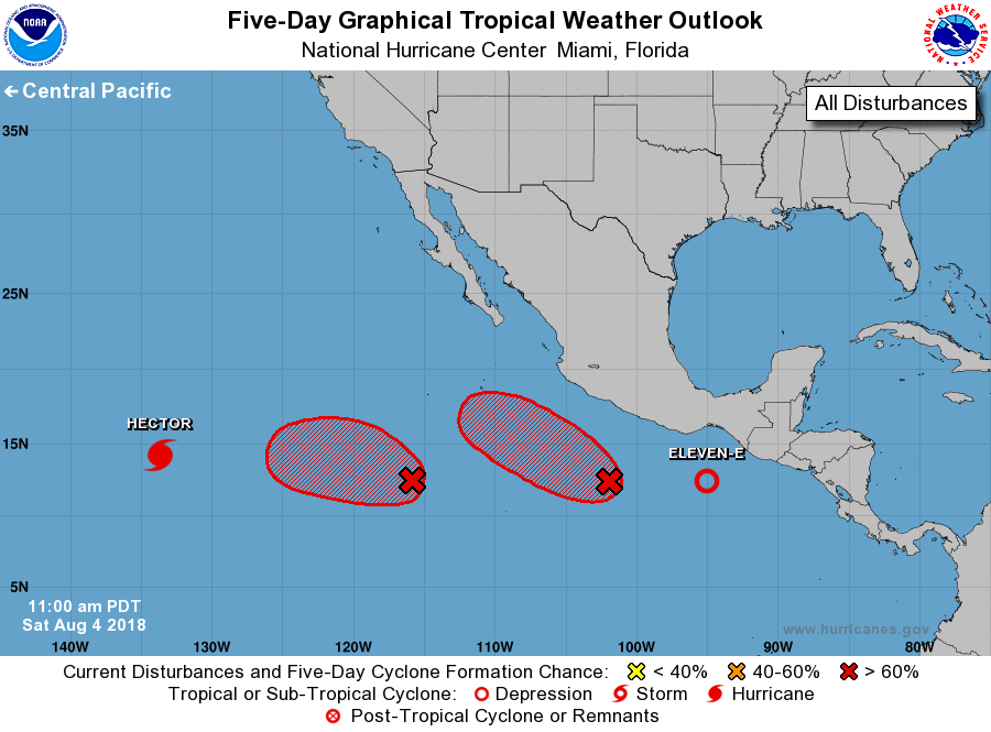
For the eastern North Pacific...east of 140 degrees west longitude:
The National Hurricane Center is issuing advisories on Hurricane
Hector, located over the far southwestern part of the basin.
1. Showers and thunderstorms associated with a broad area of low
pressure centered about 825 miles south-southwest of the southern
tip of the Baja California peninsula continue to show signs of
organization. Environmental conditions are likely to support
additional development, and a tropical depression is expected to
form by early next week as the system moves slowly westward.
* Formation chance through 48 hours...high...70 percent.
* Formation chance through 5 days...high...90 percent.
2. Satellite data indicate that a broad low pressure area has formed
several hundred miles south-southwest of Acapulco, Mexico.
Environmental conditions are conducive for significant development,
and a tropical depression or tropical storm is expected to form
tonight or tomorrow while the system moves west-northwestward
off the coast of Mexico.
* Formation chance through 48 hours...high...90 percent.
* Formation chance through 5 days...high...near 100 percent.
3. Satellite images indicate that a low pressure area located about 275
miles south-southeast of Puerto Angel, Mexico, has become
significantly better defined this morning, and a tropical depression
could be forming. If current trends continue, advisories could be
initiated this afternoon or evening on this system. The low is
forecast to move west-northwestward at 10 to 15 mph, relatively
close to Mexico, and interests along the southern coast of Mexico
should monitor the progress of this system. Heavy rainfall and
gusty winds could affect coastal regions of Guerrero northwestward
to Jalisco over the next few days.
* Formation chance through 48 hours...high...90 percent.
* Formation chance through 5 days...high...90 percent.
Forecaster Blake