ZCZC MIATWOAT ALL
TTAA00 KNHC DDHHMM
Tropical Weather Outlook
NWS National Hurricane Center Miami FL
200 AM EDT Sat Sep 30 2017
For the North Atlantic...Caribbean Sea and the Gulf of Mexico:
The National Hurricane Center is issuing advisories on Tropical
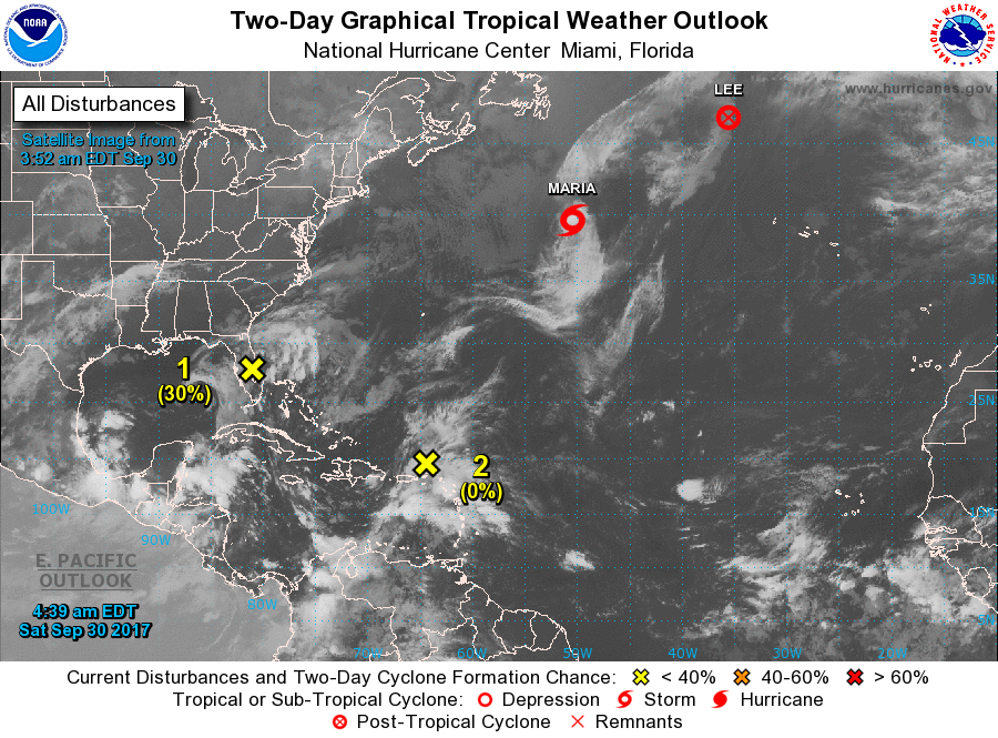
Storm Maria, located several hundred miles south of Cape Race,
Newfoundland, and on Tropical Storm Lee, located almost 1000 miles
west-northwest of the Azores.
1. The interaction of a weak low pressure area over central Florida
and an upper-level low over the Gulf of Mexico is producing
disorganized cloudiness and showers that extend from the
northwestern Caribbean Sea northward across much of the Florida
peninsula and the adjacent waters. Due to the low's interaction
with land and an expected increase of upper-level winds over the
weekend, the likelihood of this system's development appears to be
decreasing. Locally heavy rainfall is still anticipated over
portions of western Cuba, the Florida Keys, and the Florida
peninsula during the next several days while the system moves
slowly northward and then westward near northern Florida and the
northeastern Gulf of Mexico.
* Formation chance through 48 hours...low...30 percent.
* Formation chance through 5 days...low...30 percent.
2. A tropical wave interacting with an upper-level low is producing
widespread cloudiness and showers extending from the eastern
Caribbean Sea northeastward across the Lesser Antilles to the
nearby Atlantic waters. Upper-level winds are not expected to be
conducive for development while this system moves west-northwestward
to westward at 10 to 15 mph during the next few days. However,
locally heavy rainfall is expected over portions of the northern
Leeward Islands and the Greater Antilles during the next several
days, with a Flash Flood Watch in effect for Puerto Rico and the
U.S. Virgin Islands through late Sunday night.
* Formation chance through 48 hours...low...near 0 percent.
* Formation chance through 5 days...low...10 percent.
Forecaster Berg