ZCZC MIATWOAT ALL
TTAA00 KNHC DDHHMM
Tropical Weather Outlook
NWS National Hurricane Center Miami FL
800 AM EDT Wed Aug 16 2017
For the North Atlantic...Caribbean Sea and the Gulf of Mexico:
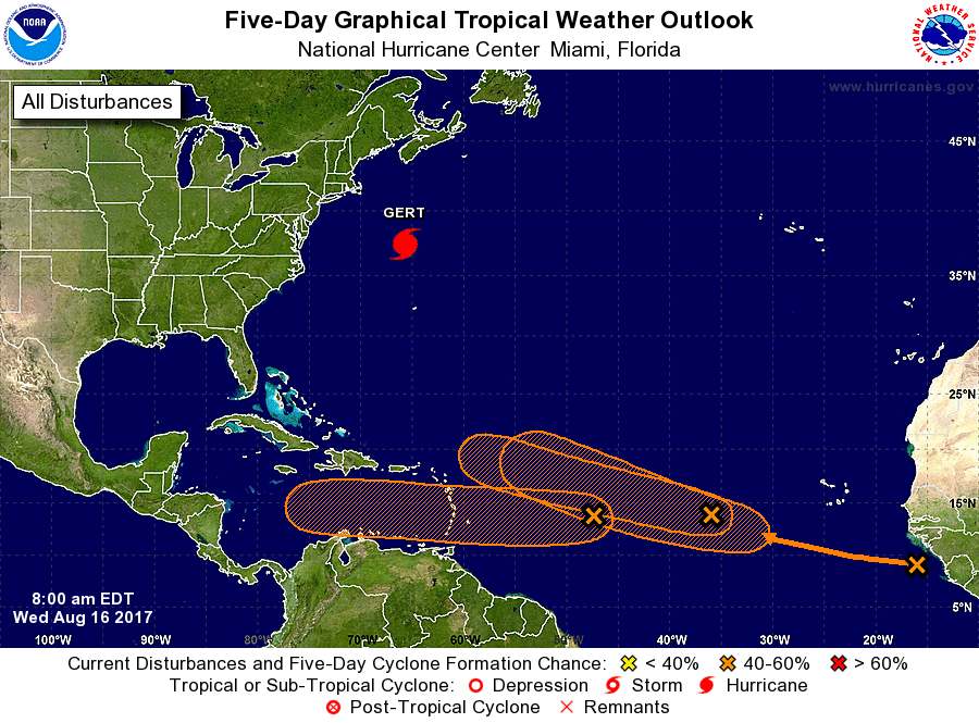
The National Hurricane Center is issuing advisories on Hurricane
Gert, located a few hundred miles northwest of Bermuda.
1. A low pressure system located about 900 miles east of the Lesser
Antilles continues to produce disorganized showers and a few
thunderstorms. This system is moving westward at 15 to 20 mph,
and it is expected to cross into the Caribbean Sea on Friday.
Upper-level winds are forecast to become a little more conducive
for development during the next several days, and interests in the
Lesser Antilles should monitor the progress of this system.
* Formation chance through 48 hours...low...30 percent.
* Formation chance through 5 days...medium...40 percent.
2. A second area of low pressure located several hundred miles west of
the Cabo Verde Islands is also producing disorganized showers and
thunderstorms. Gradual development of this system is possible
during the next few days before upper-level winds become less
conducive over the weekend. This system is expected to move
west-northwestward at 15 to 20 mph during the next several days.
* Formation chance through 48 hours...low...30 percent.
* Formation chance through 5 days...medium...40 percent.
3. A tropical wave near the west coast of Africa is producing a
large area of disorganized showers and thunderstorms.
Environmental conditions appear conducive for gradual development of
this wave while it moves westward to west-northwestward at about 15
mph during the next several days.
* Formation chance through 48 hours...low...near 0 percent.
* Formation chance through 5 days...medium...40 percent.
Forecaster Berg