ZCZC MIATWOAT ALL
TTAA00 KNHC DDHHMM
Tropical Weather Outlook
NWS National Hurricane Center Miami FL
200 PM EDT Sun Jul 30 2017
For the North Atlantic...Caribbean Sea and the Gulf of Mexico:
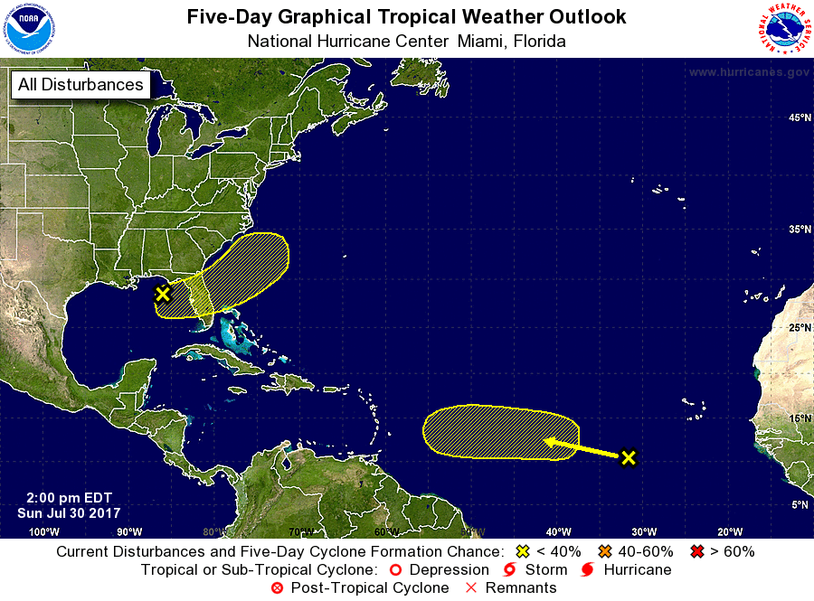
1. A tropical wave located several hundred miles west-southwest of the
Cabo Verde Islands continues to produce a large area of cloudiness
and disorganized shower activity. Some slow development of this
broad disturbance is possible over the next several days while the
system moves westward to west-northwestward at 10 to 15 mph.
* Formation chance through 48 hours...low...near 0 percent.
* Formation chance through 5 days...low...30 percent.
2. A well-defined, non-tropical low pressure system has developed over
the northeastern Gulf of Mexico about 100 miles south-southwest of
Apalachicola, Florida. Upper-level winds are only marginally
conducive for this system to acquire subtropical or tropical
characteristics tonight and Monday before it moves inland over the
central Florida peninsula on Tuesday, and into the western Atlantic
by Wednesday. Regardless of development, the low is expected to
produce locally heavy rainfall across portions of central and
northeastern Florida during the next couple of days. Please see
additional information from your local National Weather Service
Forecast Offices concerning the rainfall threat.
* Formation chance through 48 hours...low...20 percent.
* Formation chance through 5 days...low...30 percent.
Forecaster Stewart