ZCZC MIATWOEP ALL
TTAA00 KNHC DDHHMM
Tropical Weather Outlook
NWS National Hurricane Center Miami FL
1100 AM PDT Tue Jul 4 2017
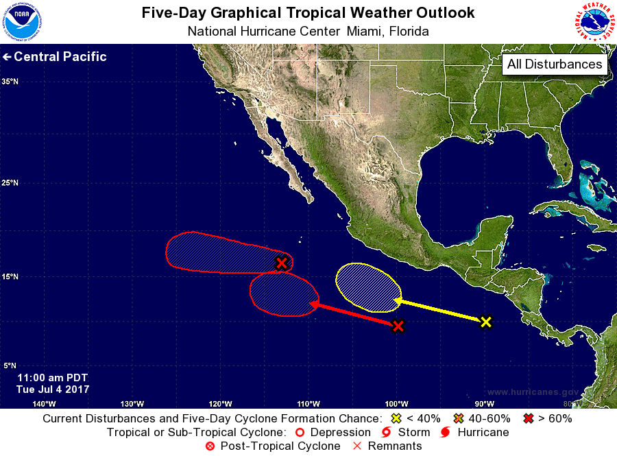
For the eastern North Pacific...east of 140 degrees west longitude:
1. Showers and thunderstorms associated with a low pressure area
located about 500 miles south-southwest of the southern tip of the
Baja California peninsula continue to show signs of organization.
This system still has the potential to become a tropical depression
during the next day or two before it moves westward into a less
favorable environment.
* Formation chance through 48 hours...high...70 percent.
* Formation chance through 5 days...high...70 percent.
2. A broad area of low pressure located several hundred miles south of
Acapulco, Mexico, continues to produce disorganized showers and
thunderstorms. Environmental conditions are forecast to be favorable
for development, and this system is likely to become a tropical
depression late this week or this weekend while the disturbance
moves generally westward at about 10 mph.
* Formation chance through 48 hours...low...near 0 percent.
* Formation chance through 5 days...high...70 percent.
3. A third area of disturbed weather is located over the far eastern
North Pacific, a few hundred miles south of the coast of El
Salvador. Development, if any, of this system should be slow to
occur while it moves westward to west-northwestward well south of
the coasts of of Central America and Mexico.
* Formation chance through 48 hours...low...near 0 percent.
* Formation chance through 5 days...low...20 percent.
Forecaster Cangialosi