ZCZC MIATWOAT ALL
TTAA00 KNHC DDHHMM
Tropical Weather Outlook
NWS National Hurricane Center Miami FL
800 AM EDT Sun Jun 18 2017
For the North Atlantic...Caribbean Sea and the Gulf of Mexico:
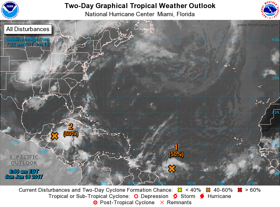
1. Showers and thunderstorms continue to show signs of organization in
association with a tropical wave located about 1000 miles
east-southeast of the southern Windward Islands. Some development
of this system is possible during the next couple of days before
environmental conditions become less favorable for tropical cyclone
formation. This system is forecast to move to the west-northwest at
near 20 mph toward the Windward Islands and northeastern South
America during the next two days, and interests in these areas
should monitor its progress. An Air Force Reserve Hurricane Hunter
aircraft is scheduled to investigate this system on Monday, if
necessary.
* Formation chance through 48 hours...medium...50 percent.
* Formation chance through 5 days...medium...50 percent.
2. A broad area of low pressure located over the northwestern Caribbean
Sea continues to produce a large area of disorganized showers and
thunderstorms. Gradual development of this system is expected while
it moves slowly northwestward across the Yucatan Peninsula later
today and over the southern or central Gulf of Mexico on Monday and
Tuesday, where a tropical or subtropical cyclone is likely to form.
Regardless of development, heavy rains are expected over portions of
Central America, the Yucatan Peninsula, Jamaica, the Cayman Islands,
and western Cuba during the next several days. An Air Force Reserve
Hurricane Hunter aircraft is scheduled to investigate this system
later today, if necessary.
* Formation chance through 48 hours...medium...60 percent.
* Formation chance through 5 days...high...90 percent.
Forecaster Beven