ZCZC MIATWOAT ALL
TTAA00 KNHC DDHHMM
TROPICAL WEATHER OUTLOOK
NWS NATIONAL HURRICANE CENTER MIAMI FL
200 AM EDT TUE SEP 13 2016
For the North Atlantic...Caribbean Sea and the Gulf of Mexico:
The National Hurricane Center is issuing advisories on Tropical
Storm Ian, located well to the east-southeast of Bermuda.
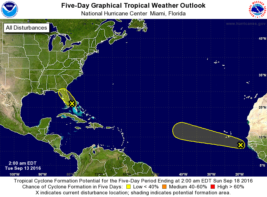
1. Satellite, radar, and surface data indicate that a weak area of low
pressure is located near West Palm Beach, Florida. The low is
producing a large area of showers and thunderstorms that extends
from the northwestern Bahamas to the southeastern coast of Florida.
Significant development of this system is unlikely since the low is
expected to move inland over the central and northern portions of
the Florida peninsula through tonight. Locally heavy rainfall and
gusty winds are likely to continue over the northwestern Bahamas
this morning, and spread over portions of the Florida peninsula
later today.
* Formation chance through 48 hours...low...10 percent
* Formation chance through 5 days...low...10 percent
2. A broad area of low pressure, associated with a tropical wave,
located a couple of hundred miles east-southeast of the Cabo Verde
Islands is producing a large area of disorganized cloudiness and
showers. Slow development of this disturbance is possible during
the next several days while it moves west-northwestward at 10 to 15
mph over the tropical Atlantic.
* Formation chance through 48 hours...low...10 percent
* Formation chance through 5 days...low...30 percent
Public Advisories on Tropical Storm Ian are issued under WMO header
WTNT35 KNHC and under AWIPS header MIATCPAT5.
Forecast/Advisories on Tropical Storm Ian are issued under WMO
header WTNT25 KNHC and under AWIPS header MIATCMAT5.
Forecaster Cangialosi/Brown