ZCZC MIATWOAT ALL
TTAA00 KNHC DDHHMM
TROPICAL WEATHER OUTLOOK
NWS NATIONAL HURRICANE CENTER MIAMI FL
200 AM EDT MON SEP 12 2016
For the North Atlantic...Caribbean Sea and the Gulf of Mexico:
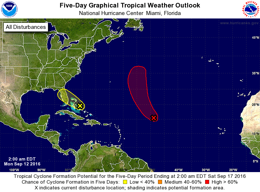
1. Satellite derived wind data indicate that the low pressure system
located about 900 miles east-northeast of the northern Leeward
Islands is producing an area of gale-force winds, but the center
of circulation is not well defined. The associated showers and
thunderstorms continue to gradually increase and have become a
little better organized during the past several hours. If the
the circulation of the system becomes better defined, a tropical
storm could form later today before upper-level winds become less
conducive for development. The low is expected to move
northwestward or north-northwestward at 10 to 15 mph over the
central Atlantic Ocean during the next few days. For additional
information on this system, see High Seas Forecasts issued by the
National Weather Service.
* Formation chance through 48 hours...high...80 percent
* Formation chance through 5 days...high...90 percent
2. Disorganized shower activity continues in association with a
disturbance near the central Bahamas. Surface pressures remain high
in the area, and there are still no signs of a closed surface
circulation. Conditions do not appear conducive for significant
development of this disturbance while it moves west-northwestward at
10 to 15 mph. However, locally heavy rainfall is possible over
portions of the central and northwestern Bahamas today, and
portions of the Florida peninsula on Tuesday.
* Formation chance through 48 hours...low...10 percent
* Formation chance through 5 days...low...10 percent
High Seas Forecasts issued by the National Weather Service can be
found under AWIPS header NFDHSFAT1, WMO header FZNT01 KWBC, and
on the Web at http://www.opc.ncep.noaa.gov/shtml/NFDHSFAT1.shtml.
Forecaster Cangialosi