ZCZC MIATWOAT ALL
TTAA00 KNHC DDHHMM
TROPICAL WEATHER OUTLOOK
NWS NATIONAL HURRICANE CENTER MIAMI FL
800 AM EDT SUN SEP 11 2016
For the North Atlantic...Caribbean Sea and the Gulf of Mexico:
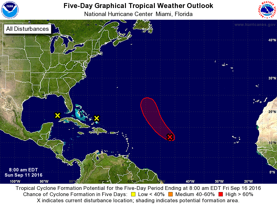
1. A low pressure system located about 1000 miles east of the Leeward
Islands is producing a large area of cloudiness and showers, but
it currently has limited thunderstorm activity near the center of
circulation. However, a tropical depression is still likely to
form later today or on Monday before upper-level winds become less
conducive for development. The low is expected to move
northwestward or north-northwestward at 10 to 15 mph over the
central Atlantic Ocean during the next few days.
* Formation chance through 48 hours...high...70 percent
* Formation chance through 5 days...high...80 percent
2. Showers and thunderstorms have increased with a disturbance located
near the southeastern Bahamas. However, there are still no signs of
a surface circulation, and conditions do not appear conducive for
significant development of this disturbance while it moves west-
northwestward at 10 to 15 mph. Heavy rainfall is possible over
portions of the Bahamas today and on Monday.
* Formation chance through 48 hours...low...near 0 percent
* Formation chance through 5 days...low...near 0 percent
3. A few showers and thunderstorms have re-formed near a weak area of
low pressure located over southeastern Gulf of Mexico. However,
upper-level winds will not be conducive for development of this
system while it moves generally westward across the Gulf of Mexico
during the next few days at 5 to 10 mph.
* Formation chance through 48 hours...low...near 0 percent
* Formation chance through 5 days...low...near 0 percent
Forecaster Berg