ZCZC MIATWOAT ALL
TTAA00 KNHC DDHHMM
TROPICAL WEATHER OUTLOOK
NWS NATIONAL HURRICANE CENTER MIAMI FL
200 PM EDT SAT SEP 10 2016
For the North Atlantic...Caribbean Sea and the Gulf of Mexico:
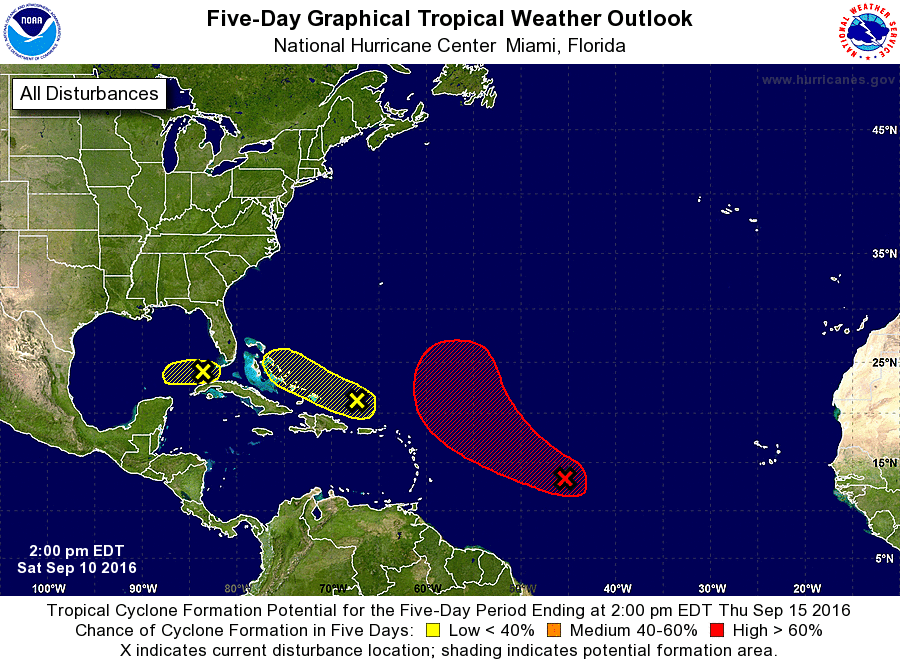
1. A broad area of low pressure located a little more than 1000 miles
east of the Lesser Antilles has been moving slowly toward the
west-northwest. The circulation appears to be better defined today,
but the thunderstorm activity near the center remains poorly
organized. Conditions are still very favorable for a tropical
depression to form by Sunday or Monday while this disturbance moves
toward the west-northwest or northwest over the central Atlantic
during the next several days.
* Formation chance through 48 hours...high...80 percent
* Formation chance through 5 days...high...90 percent
2. An area of cloudiness and thunderstorms located north of Puerto Rico
and Hispaniola remains disorganized. There are no signs of a
surface circulation, and conditions are not expected to be conducive
for significant development of this system while it moves generally
west-northwestward at around 15 mph.
* Formation chance through 48 hours...low...10 percent
* Formation chance through 5 days...low...10 percent
3. An area of low pressure located over the extreme southeastern Gulf
of Mexico is devoid of thunderstorm activity. Upper-level winds are
not favorable for development, and the low is forecast to weaken
further while it moves westward across the central Gulf of Mexico
at 5 to 10 mph.
* Formation chance through 48 hours...low...10 percent
* Formation chance through 5 days...low...10 percent
Forecaster Avila