ZCZC MIATWOAT ALL
TTAA00 KNHC DDHHMM
TROPICAL WEATHER OUTLOOK
NWS NATIONAL HURRICANE CENTER MIAMI FL
800 PM EDT FRI SEP 9 2016
For the North Atlantic...Caribbean Sea and the Gulf of Mexico:
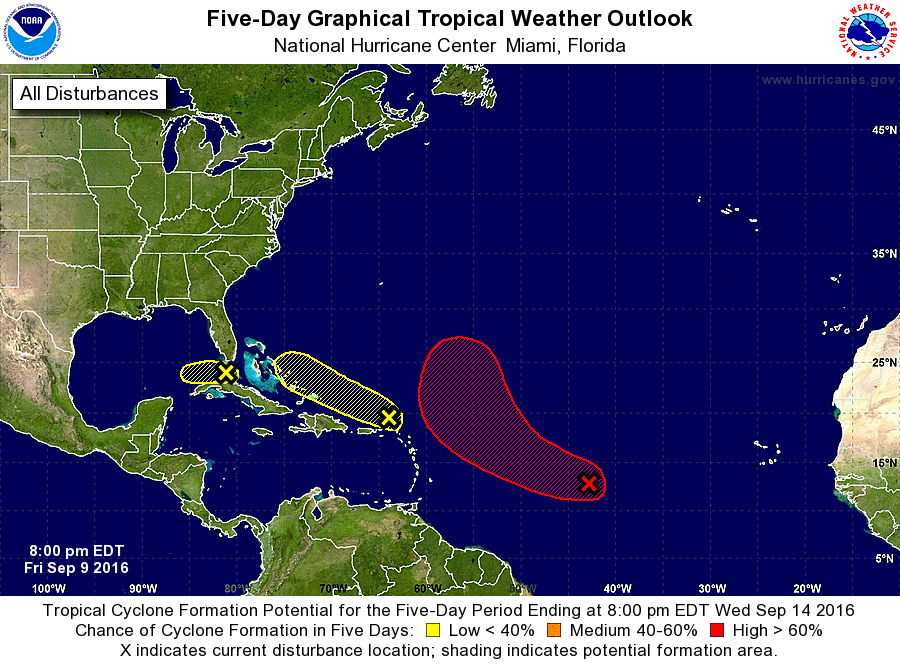
1. Shower and thunderstorm activity has increased during the past 24
hours in association with a broad area of low pressure located about
1200 miles east of the Lesser Antilles. Environmental conditions
are forecast to be favorable for additional development, and a
tropical depression is likely to form this weekend or early next
week while this disturbance moves toward the west-northwest and
then toward the northwest over the central Atlantic during the next
several days.
* Formation chance through 48 hours...high...70 percent
* Formation chance through 5 days...high...90 percent
2. An area of cloudiness, showers, and thunderstorms located just north
of the northern Leeward Islands and Puerto Rico is not showing any
signs of organization. Environmental conditions are not expected to
be conducive for significant development of this system while it
moves generally west-northwestward at around 15 mph.
* Formation chance through 48 hours...low...10 percent
* Formation chance through 5 days...low...10 percent
3. Due to strong upper-level winds, shower and thunderstorm activity
has become less organized and is now located farther southeast of an
area of low pressure located just south of the lower Florida Keys.
Upper-level winds are expected to remain unfavorable for significant
development while this system moves westward at 5 to 10 mph into the
southeastern Gulf of Mexico during the next couple of days.
However, squalls and gusty winds are possible in portions of the
Florida Keys tonight and Saturday. For additional information on
this system, see High Seas Forecasts issued by the National Weather
Service.
* Formation chance through 48 hours...low...30 percent
* Formation chance through 5 days...low...30 percent
High Seas Forecasts issued by the National Weather Service can be
found under AWIPS header NFDHSFAT1, WMO header FZNT01 KWBC, and
on the Web at http://www.opc.ncep.noaa.gov/shtml/NFDHSFAT1.shtml.
Forecaster Brennan