Skip Navigation Links
NOAA NOAA United States Department of Commerce

NHC Graphical Outlook Archive


« Earliest Available         ‹ Earlier         Later ›         Latest Available »
GIS Shapefiles
tab Eastern North Pacific tab tab Atlantic tab

View 2-Day Graphical Tropical Weather Outlook
Click for Eastern North Pacific Click for Eastern North Pacific

Tropical Weather Outlook Text

ZCZC MIATWOAT ALL
TTAA00 KNHC DDHHMM

TROPICAL WEATHER OUTLOOK
NWS NATIONAL HURRICANE CENTER MIAMI FL
200 PM EDT WED SEP 7 2016

For the North Atlantic...Caribbean Sea and the Gulf of Mexico:

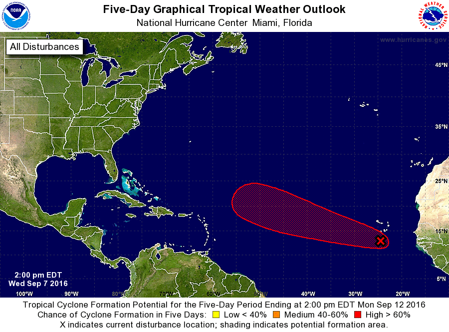
1. A tropical wave near the Cabo Verde Islands is accompanied by
disorganized showers and thunderstorms. No significant development
is expected during the next couple of days. However, conditions are
forecast to become a little more favorable for gradual development,
and a tropical depression could form by the weekend while this
system moves west-northwestward toward the central Atlantic.
* Formation chance through 48 hours...low...20 percent
* Formation chance through 5 days...high...70 percent

Forecaster Avila


List of Atlantic Outlooks (May 2023 - present)
List of East Pacific Outlooks (May 2023 - present)
List of Central Pacific Outlooks (May 2023 - present)
List of Atlantic Outlooks (July 2014 - April 2023)
List of East Pacific Outlooks (July 2014 - April 2023)
List of Central Pacific Outlooks (June 2019 - April 2023)
List of Atlantic Outlooks (June 2009 - June 2014)
List of East Pacific Outlooks (June 2009 - June 2014)