ZCZC MIATWOAT ALL
TTAA00 KNHC DDHHMM
TROPICAL WEATHER OUTLOOK
NWS NATIONAL HURRICANE CENTER MIAMI FL
200 AM EDT SAT JUL 30 2016
For the North Atlantic...Caribbean Sea and the Gulf of Mexico:
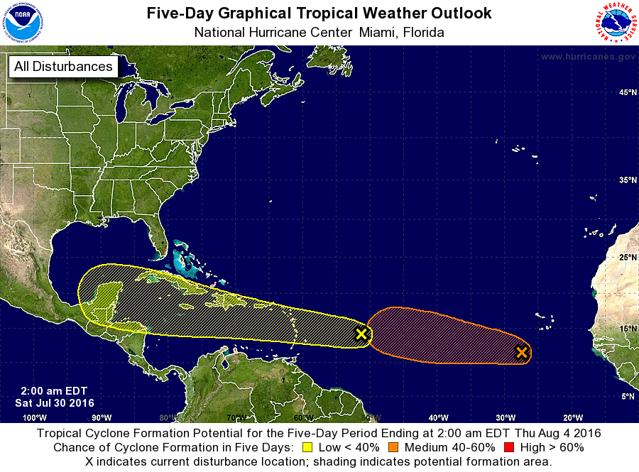
1. A tropical wave located about 850 miles east of the Lesser Antilles
is moving westward at 25 to 30 mph. Associated shower activity is
poorly organized, and given the fast motion of the system any
development should be slow to occur. Regardless of development,
this system will likely bring showers and gusty winds to portions of
the Leeward Islands, Virgin Islands, Puerto Rico, and the eastern
Caribbean Sea during the weekend. By the middle of next week, the
disturbance is expected to be in the western Caribbean Sea, where
conditions could become more conducive for development.
* Formation chance through 48 hours...low...10 percent
* Formation chance through 5 days...low...30 percent
2. Shower and thunderstorm activity associated with a tropical wave
and a low pressure system centered a couple of hundred miles
south-southwest of Cabo Verde continues to show signs of
organization. Although this system does not have a well-defined
circulation at this time, some development is still possible during
the next day or two before the disturbance encounters a less
favorable environment over the central tropical Atlantic early
next week.
* Formation chance through 48 hours...medium...40 percent
* Formation chance through 5 days...medium...50 percent
Forecaster Stewart