


NHC Graphical Outlook Archive
|
« Earliest Available ‹ Earlier Later › Latest Available » |
GIS Shapefiles |
| Eastern North Pacific | Atlantic |
|
Tropical Weather Outlook Text
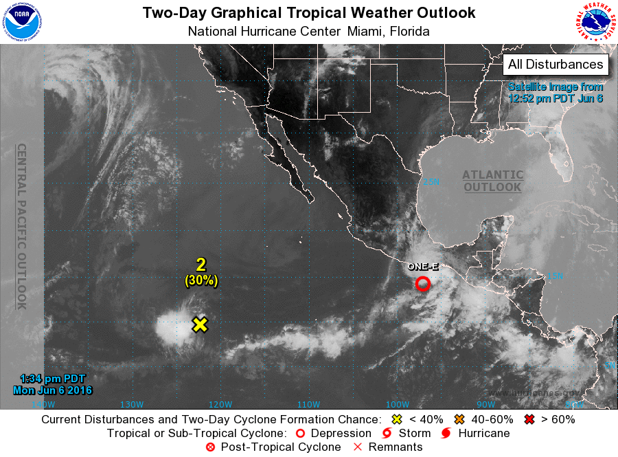
ZCZC MIATWOEP ALL
TTAA00 KNHC DDHHMM

SPECIAL TROPICAL WEATHER OUTLOOK
NWS NATIONAL HURRICANE CENTER MIAMI FL
1120 AM PDT MON JUN 6 2016

For the eastern North Pacific...east of 140 degrees west longitude:

Special outlook to update discussion of low pressure near Mexico.

1. Updated: Recent satellite data indicate that the low pressure system
located about 250 miles southeast of Acapulco, Mexico has become a
tropical depression.  Advisories will be initiated on this system
this afternoon, and tropical storm watches or warnings could be
required for a portion of the coast of southern Mexico.
* Formation chance through 48 hours...high...near 100 percent
* Formation chance through 5 days...high...near 100 percent

2. The low pressure system located about 1200 miles southwest of the
southern tip of the Baja California peninsula continues to
move slowly westward.  The associated showers and thunderstorms have
been persistent to the west of the center, but are not well
organized. However, some development of this system is possible
during the next day or two before environmental conditions become
less conducive.
* Formation chance through 48 hours...low...30 percent
* Formation chance through 5 days...low...30 percent

Forecaster Cangialosi
List of Atlantic Outlooks (May 2023 - present)
List of East Pacific Outlooks (May 2023 - present)
List of Central Pacific Outlooks (May 2023 - present)
List of Atlantic Outlooks (July 2014 - April 2023)
List of East Pacific Outlooks (July 2014 - April 2023)
List of Central Pacific Outlooks (June 2019 - April 2023)
List of Atlantic Outlooks (June 2009 - June 2014)
List of East Pacific Outlooks (June 2009 - June 2014)