


NHC Graphical Outlook Archive
|
« Earliest Available ‹ Earlier Later › Latest Available » |
GIS Shapefiles |
| Eastern North Pacific | Atlantic |
|
Tropical Weather Outlook Text
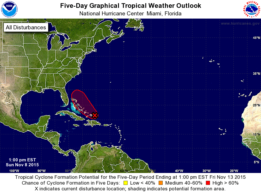
ZCZC MIATWOAT ALL
TTAA00 KNHC DDHHMM

TROPICAL WEATHER OUTLOOK
NWS NATIONAL HURRICANE CENTER MIAMI FL
100 PM EST SUN NOV 8 2015

For the North Atlantic...Caribbean Sea and the Gulf of Mexico:

1. Shower and thunderstorm activity is showing signs of organization
in association with a low pressure system located just north of
the Turks and Caicos and the southeastern Bahamas.  In addition,
satellite images indicate that the circulation of the low is
becoming better defined.  Environmental conditions are expected
to be conducive for development of this system, and a tropical
depression or a tropical storm is likely to form tonight or on
Monday while the low moves west-northwestward to northwestward
near or over the central and northwestern Bahamas.  Locally heavy
rains and gusty winds are possible across the Turks and Caicos and
most of the Bahamas during the next day or so. An Air Force Reserve
hurricane hunter aircraft is scheduled to investigate this system
Monday morning.
* Formation chance through 48 hours...high...70 percent
* Formation chance through 5 days...high...70 percent

Forecaster Cangialosi/Stewart
List of Atlantic Outlooks (May 2023 - present)
List of East Pacific Outlooks (May 2023 - present)
List of Central Pacific Outlooks (May 2023 - present)
List of Atlantic Outlooks (July 2014 - April 2023)
List of East Pacific Outlooks (July 2014 - April 2023)
List of Central Pacific Outlooks (June 2019 - April 2023)
List of Atlantic Outlooks (June 2009 - June 2014)
List of East Pacific Outlooks (June 2009 - June 2014)