


NHC Graphical Outlook Archive
|
« Earliest Available ‹ Earlier Later › Latest Available » |
GIS Shapefiles |
| Eastern North Pacific | Atlantic |
|
Tropical Weather Outlook Text
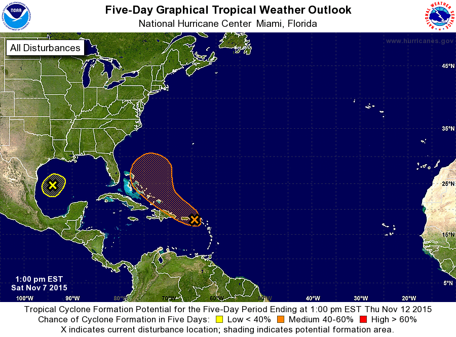
ZCZC MIATWOAT ALL
TTAA00 KNHC DDHHMM

TROPICAL WEATHER OUTLOOK
NWS NATIONAL HURRICANE CENTER MIAMI FL
100 PM EST SAT NOV 7 2015

For the North Atlantic...Caribbean Sea and the Gulf of Mexico:

1. A broad low pressure area is centered about 225 miles east-southeast
of Brownsville, Texas.  The associated thunderstorm activity is
currently disorganized, and the Air Force Reserve Hurricane Hunter
mission scheduled for this afternoon has been canceled.  However,
there is still some potential for development this afternoon and
tonight before the low merges with a cold front on Sunday.
* Formation chance through 48 hours...low...20 percent
* Formation chance through 5 days...low...20 percent

2. A large area of cloudiness and showers extending from the
northeastern Caribbean Sea across the Lesser Antilles into the
Atlantic is associated with the interaction of an upper-level trough
and a west-northwestward moving tropical wave.  There are no signs
of organization at this time.  However, some gradual development of
this disturbance is possible by early next week when it is forecast
to be near or east of the Bahamas.  Regardless of development,
locally heavy rains are possible over the Lesser Antilles, the
Virgin Islands, Puerto Rico, and Hispaniola during the next few
days.
* Formation chance through 48 hours...low...20 percent
* Formation chance through 5 days...medium...50 percent

Forecaster Beven
List of Atlantic Outlooks (May 2023 - present)
List of East Pacific Outlooks (May 2023 - present)
List of Central Pacific Outlooks (May 2023 - present)
List of Atlantic Outlooks (July 2014 - April 2023)
List of East Pacific Outlooks (July 2014 - April 2023)
List of Central Pacific Outlooks (June 2019 - April 2023)
List of Atlantic Outlooks (June 2009 - June 2014)
List of East Pacific Outlooks (June 2009 - June 2014)