


NHC Graphical Outlook Archive
|
« Earliest Available ‹ Earlier Later › Latest Available » |
GIS Shapefiles |
| Eastern North Pacific | Atlantic |
|
Tropical Weather Outlook Text
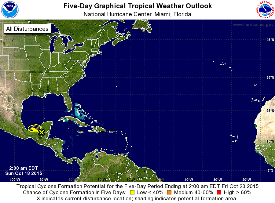
ZCZC MIATWOAT ALL
TTAA00 KNHC DDHHMM

TROPICAL WEATHER OUTLOOK
NWS NATIONAL HURRICANE CENTER MIAMI FL
200 AM EDT SUN OCT 18 2015

For the North Atlantic...Caribbean Sea and the Gulf of Mexico:

1. An area of low pressure located inland over southeastern Mexico
about 70 miles southeast of Ciudad del Carmen is producing
disorganized showers and a few thunderstorms across portions of the
northwestern Caribbean Sea and the Yucatan Peninsula.  This system
is moving slowly to the west-northwest, and some development is
possible later today or on Monday if the low emerges into the
southern Bay of Campeche. An Air Force Reserve Hurricane Hunter
aircraft is scheduled to investigate this system this afternoon, if
necessary. Regardless of tropical cyclone formation, this system
will likely produce heavy rainfall across portions of Belize,
northern Guatemala, the Yucatan Peninsula, and southeastern Mexico
through Monday.
* Formation chance through 48 hours...low...20 percent
* Formation chance through 5 days...low...20 percent

Forecaster Blake
List of Atlantic Outlooks (May 2023 - present)
List of East Pacific Outlooks (May 2023 - present)
List of Central Pacific Outlooks (May 2023 - present)
List of Atlantic Outlooks (July 2014 - April 2023)
List of East Pacific Outlooks (July 2014 - April 2023)
List of Central Pacific Outlooks (June 2019 - April 2023)
List of Atlantic Outlooks (June 2009 - June 2014)
List of East Pacific Outlooks (June 2009 - June 2014)