


NHC Graphical Outlook Archive
|
« Earliest Available ‹ Earlier Later › Latest Available » |
GIS Shapefiles |
| Eastern North Pacific | Atlantic |
|
Tropical Weather Outlook Text
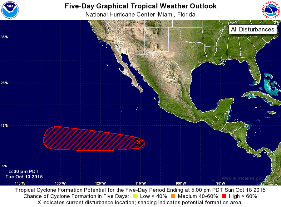
ZCZC MIATWOEP ALL
TTAA00 KNHC DDHHMM

TROPICAL WEATHER OUTLOOK
NWS NATIONAL HURRICANE CENTER MIAMI FL
500 PM PDT TUE OCT 13 2015

For the eastern North Pacific...east of 140 degrees west longitude:

1. Showers and thunderstorms have increased since yesterday in
association with an area of low pressure located about 850 miles
south of the southern tip of the Baja California peninsula.
Environmental conditions are expected to be conducive for
development, and a tropical depression is likely to form later
this week or this weekend while the low moves westward at 10 to 15
mph.
* Formation chance through 48 hours...medium...40 percent
* Formation chance through 5 days...high...80 percent

Forecaster Cangialosi
List of Atlantic Outlooks (May 2023 - present)
List of East Pacific Outlooks (May 2023 - present)
List of Central Pacific Outlooks (May 2023 - present)
List of Atlantic Outlooks (July 2014 - April 2023)
List of East Pacific Outlooks (July 2014 - April 2023)
List of Central Pacific Outlooks (June 2019 - April 2023)
List of Atlantic Outlooks (June 2009 - June 2014)
List of East Pacific Outlooks (June 2009 - June 2014)