


NHC Graphical Outlook Archive
|
« Earliest Available ‹ Earlier Later › Latest Available » |
GIS Shapefiles |
| Eastern North Pacific | Atlantic |
|
Tropical Weather Outlook Text
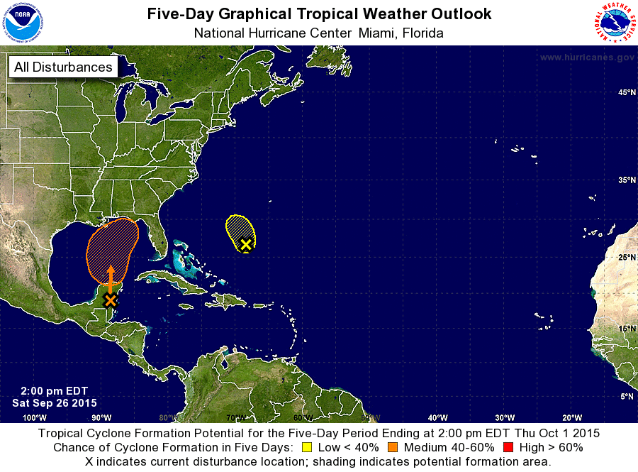
ZCZC MIATWOAT ALL
TTAA00 KNHC DDHHMM

TROPICAL WEATHER OUTLOOK
NWS NATIONAL HURRICANE CENTER MIAMI FL
200 PM EDT SAT SEP 26 2015

For the North Atlantic...Caribbean Sea and the Gulf of Mexico:

The National Hurricane Center is issuing advisories on Tropical
Depression Ida, located a little more than 1000 miles east-northeast
of the northern Leeward Islands.

1. Visible satellite images and surface observations indicate that a
low pressure area has formed over the southeastern portion of the
Yucatan Peninsula.  This low is producing disorganized showers and
thunderstorms and gusty winds over portions of the northwestern
Caribbean Sea and the Yucatan Peninsula. This system is expected to
reach the southern Gulf of Mexico on Sunday and should continue to
move northward thereafter while it interacts with an upper-level low
near the Texas coast.  During this interaction, there is some
potential for the system to become a tropical cyclone. Regardless
of tropical cyclone formation, this disturbance is likely to produce
locally heavy rainfall over portions of the northern Gulf coast and
southeastern United States early next week.  An Air Force Reserve
reconnaissance aircraft is scheduled to investigate this system on
Sunday, if necessary.
* Formation chance through 48 hours...low...30 percent
* Formation chance through 5 days...medium...40 percent

2. Disorganized showers and thunderstorms over the western Atlantic
Ocean several hundred miles south-southwest of Bermuda are
associated with an upper-level low and a surface trough.  Some
slow development of this system is possible during the next
day or two while it moves toward the north or north-northwest.
After that time, development is not expected due to unfavorable
upper-level winds.
* Formation chance through 48 hours...low...20 percent
* Formation chance through 5 days...low...20 percent

Forecaster Cangialosi/Beven
List of Atlantic Outlooks (May 2023 - present)
List of East Pacific Outlooks (May 2023 - present)
List of Central Pacific Outlooks (May 2023 - present)
List of Atlantic Outlooks (July 2014 - April 2023)
List of East Pacific Outlooks (July 2014 - April 2023)
List of Central Pacific Outlooks (June 2019 - April 2023)
List of Atlantic Outlooks (June 2009 - June 2014)
List of East Pacific Outlooks (June 2009 - June 2014)