


NHC Graphical Outlook Archive
|
« Earliest Available ‹ Earlier Later › Latest Available » |
GIS Shapefiles |
| Eastern North Pacific | Atlantic |
|
Tropical Weather Outlook Text
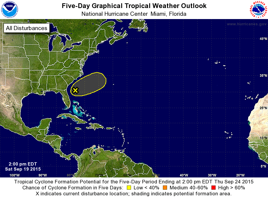
ZCZC MIATWOAT ALL
TTAA00 KNHC DDHHMM

TROPICAL WEATHER OUTLOOK
NWS NATIONAL HURRICANE CENTER MIAMI FL
200 PM EDT SAT SEP 19 2015

For the North Atlantic...Caribbean Sea and the Gulf of Mexico:

The National Hurricane Center is issuing advisories on Tropical
Depression Nine, located several hundred miles east-northeast
of the Lesser Antilles, and on Tropical Storm Ida, located about a
thousand miles west of the Cape Verde Islands.

1. A broad area of low pressure located about 200 miles east of the
northeast Florida coast continues to produce disorganized cloudiness
and thunderstorms well to the east and south of the center.
Environmental conditions are expected to be only marginally
conducive for this low to acquire subtropical or tropical
characteristics during the next few days while it moves slowly
northeastward off the southeast coast of the United States. An Air
Force Reserve Hurricane Hunter aircraft is scheduled to investigate
this system tomorrow, if necessary. For more information on this
low, see High Seas Forecasts issued by the National Weather Service.
* Formation chance through 48 hours...low...20 percent
* Formation chance through 5 days...low...30 percent

High Seas Forecasts issued by the National Weather Service are
available under AWIPS header NFDHSFAT1, WMO header FZNT01 KWBC, and
on the Web at http://www.opc.ncep.noaa.gov/shtml/NFDHSFAT1.shtml.

Forecaster Brennan
List of Atlantic Outlooks (May 2023 - present)
List of East Pacific Outlooks (May 2023 - present)
List of Central Pacific Outlooks (May 2023 - present)
List of Atlantic Outlooks (July 2014 - April 2023)
List of East Pacific Outlooks (July 2014 - April 2023)
List of Central Pacific Outlooks (June 2019 - April 2023)
List of Atlantic Outlooks (June 2009 - June 2014)
List of East Pacific Outlooks (June 2009 - June 2014)