


NHC Graphical Outlook Archive
|
« Earliest Available ‹ Earlier Later › Latest Available » |
GIS Shapefiles |
| Eastern North Pacific | Atlantic |
|
Tropical Weather Outlook Text
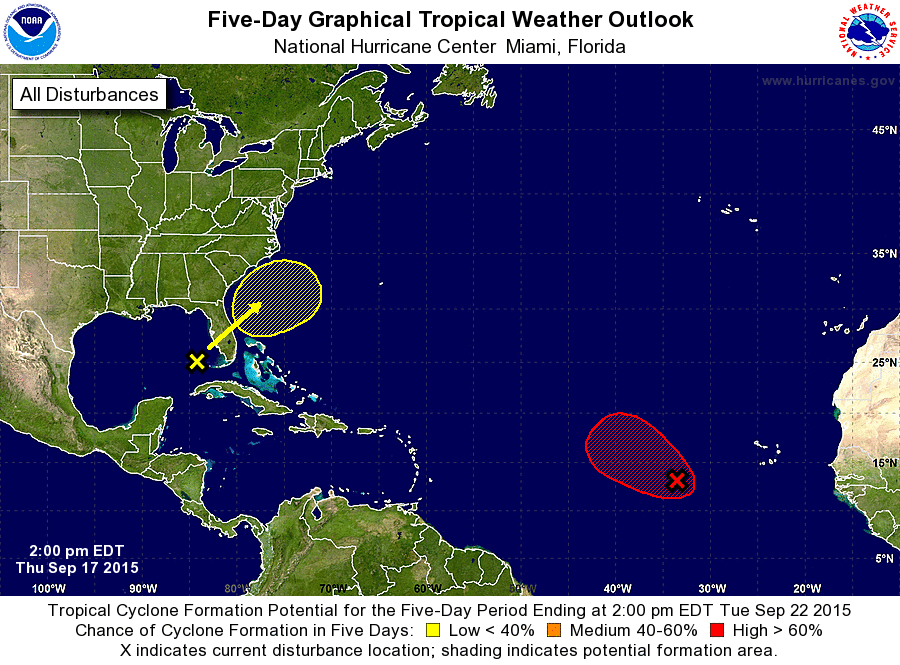
ZCZC MIATWOAT ALL
TTAA00 KNHC DDHHMM

TROPICAL WEATHER OUTLOOK
NWS NATIONAL HURRICANE CENTER MIAMI FL
200 PM EDT THU SEP 17 2015

For the North Atlantic...Caribbean Sea and the Gulf of Mexico:

The National Hurricane Center is issuing advisories on Tropical
Depression Nine, located in the central tropical Atlantic.

1. Shower activity associated with a broad area of low pressure located
about 650 miles west-southwest of the Cape Verde Islands has changed
little in organization during the past few hours. Environmental
conditions are expected to be conducive for the formation of a
tropical depression during the next day or two while this system
moves west-northwestward at 10 to 15 mph over the central tropical
Atlantic. After that time, conditions could become less conducive
for tropical cyclone formation.
* Formation chance through 48 hours...high...70 percent
* Formation chance through 5 days...high...70 percent

2. A large area of cloudiness, showers, and thunderstorms extending
from the eastern Gulf of Mexico across the Florida peninsula and
into the southwestern Atlantic Ocean is associated with a broad
surface low interacting with an upper-level trough. This weather
system will move generally northeastward and continue to produce
heavy rainfall across portions of Florida through Friday. This
weekend and early next week an area of low pressure is expected to
form off the southeast United States coast, where conditions could
become somewhat conducive for subtropical or tropical cyclone
development. For more information on this system, see products from
your local National Weather Service office.
* Formation chance through 48 hours...low...10 percent
* Formation chance through 5 days...low...30 percent

Forecaster Brennan
List of Atlantic Outlooks (May 2023 - present)
List of East Pacific Outlooks (May 2023 - present)
List of Central Pacific Outlooks (May 2023 - present)
List of Atlantic Outlooks (July 2014 - April 2023)
List of East Pacific Outlooks (July 2014 - April 2023)
List of Central Pacific Outlooks (June 2019 - April 2023)
List of Atlantic Outlooks (June 2009 - June 2014)
List of East Pacific Outlooks (June 2009 - June 2014)