


NHC Graphical Outlook Archive
|
« Earliest Available ‹ Earlier Later › Latest Available » |
GIS Shapefiles |
| Eastern North Pacific | Atlantic |
|
Tropical Weather Outlook Text
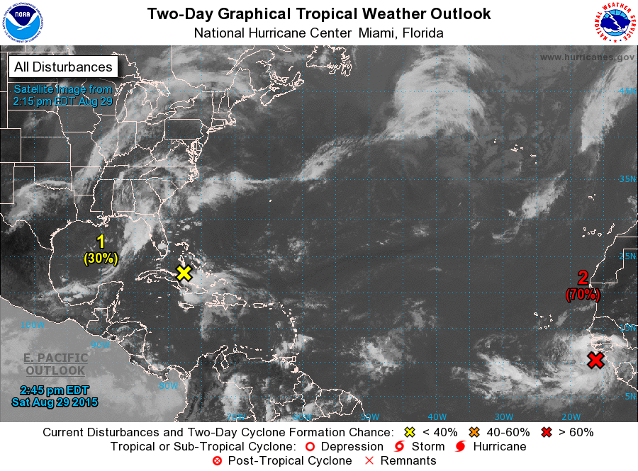
ZCZC MIATWOAT ALL
TTAA00 KNHC DDHHMM

TROPICAL WEATHER OUTLOOK
NWS NATIONAL HURRICANE CENTER MIAMI FL
200 PM EDT SAT AUG 29 2015

For the North Atlantic...Caribbean Sea and the Gulf of Mexico:

1. The National Hurricane Center has issued the last advisory on
Tropical Storm Erika.  The remnants of Erika, a trough of low
pressure, are currently located near central Cuba and the central
Bahamas and moving west-northwestward at 20 to 25 mph.  This system
is producing disorganized thunderstorm activity, and recent
satellite wind data indicate it is producing winds to tropical storm
force.  Upper-level winds are currently not favorable for
re-development of the system into a tropical cyclone.  However,
conditions may become more conducive Sunday or Monday while it moves
northwestward to northward over the eastern Gulf of Mexico.
Regardless of re-development, the remnants of Erika are expected to
spread locally heavy rains and gusty winds across portions of the
Bahamas, central and eastern Cuba, and central and southern Florida
during the next couple of days.  Additional information on this
system can be found in marine forecasts and local forecast products
issued by the National Weather Service and the meteorological
services of Cuba and the Bahamas.
* Formation chance through 48 hours...low...30 percent
* Formation chance through 5 days...medium...40 percent

2. Shower and thunderstorm activity associated with a low pressure
area located about 175 miles west of Conakry, Guinea, continue to
become better organized.   A tropical depression could form during
the next day or so while the system moves northwestward and then
west-northwestward toward the Cape Verde Islands at 10 to 15 mph.
Interests in the Cape Verde Islands should monitor the progress of
this system.
* Formation chance through 48 hours...high...70 percent
* Formation chance through 5 days...high...90 percent

Forecaster Beven
List of Atlantic Outlooks (May 2023 - present)
List of East Pacific Outlooks (May 2023 - present)
List of Central Pacific Outlooks (May 2023 - present)
List of Atlantic Outlooks (July 2014 - April 2023)
List of East Pacific Outlooks (July 2014 - April 2023)
List of Central Pacific Outlooks (June 2019 - April 2023)
List of Atlantic Outlooks (June 2009 - June 2014)
List of East Pacific Outlooks (June 2009 - June 2014)