


NHC Graphical Outlook Archive
|
« Earliest Available ‹ Earlier Later › Latest Available » |
GIS Shapefiles |
| Eastern North Pacific | Atlantic |
|
Tropical Weather Outlook Text
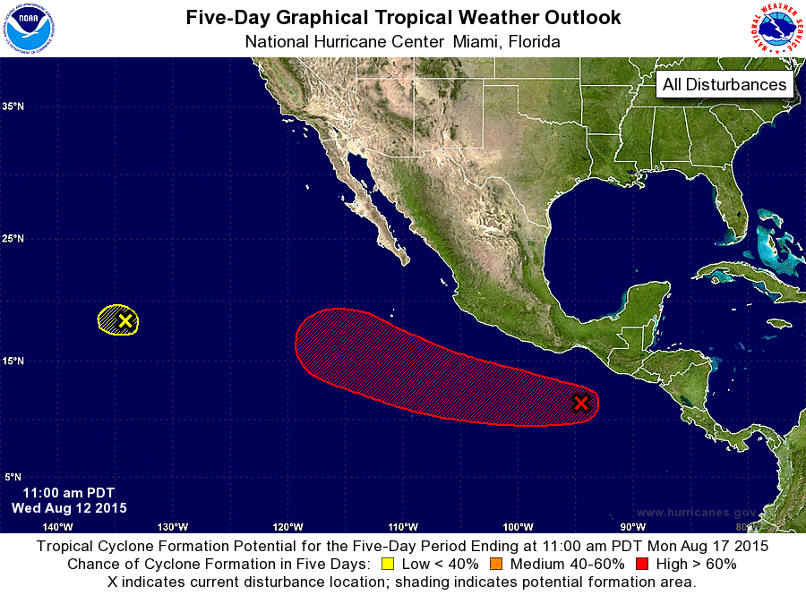
ZCZC MIATWOEP ALL
TTAA00 KNHC DDHHMM

TROPICAL WEATHER OUTLOOK
NWS NATIONAL HURRICANE CENTER MIAMI FL
1100 AM PDT WED AUG 12 2015

For the eastern North Pacific...east of 140 degrees west longitude:

1. A tropical wave located south of the southeastern coast of Mexico
is producing disorganized showers and thunderstorms. An area of low
pressure is forecast to form in association with this wave within a
couple of days a few hundred miles south-southwest of the coast of
Mexico. Environmental conditions should support development by later
this week, and a tropical cyclone will likely form late this weekend
or early next week while the low moves west-northwestward at about
15 mph.
* Formation chance through 48 hours...low...30 percent
* Formation chance through 5 days...high...90 percent

2. Shower and thunderstorm activity has decreased this morning in
association with a low pressure area located about 1300 miles
east of the Big Island of Hawaii. Development of this system is
unlikely due to unfavorable environmental conditions while it moves
westward at about 10 mph.
* Formation chance through 48 hours...low...10 percent
* Formation chance through 5 days...low...10 percent

Forecaster Brennan
List of Atlantic Outlooks (May 2023 - present)
List of East Pacific Outlooks (May 2023 - present)
List of Central Pacific Outlooks (May 2023 - present)
List of Atlantic Outlooks (July 2014 - April 2023)
List of East Pacific Outlooks (July 2014 - April 2023)
List of Central Pacific Outlooks (June 2019 - April 2023)
List of Atlantic Outlooks (June 2009 - June 2014)
List of East Pacific Outlooks (June 2009 - June 2014)