


NHC Graphical Outlook Archive
|
« Earliest Available ‹ Earlier Later › Latest Available » |
GIS Shapefiles |
| Eastern North Pacific | Atlantic |
|
Tropical Weather Outlook Text
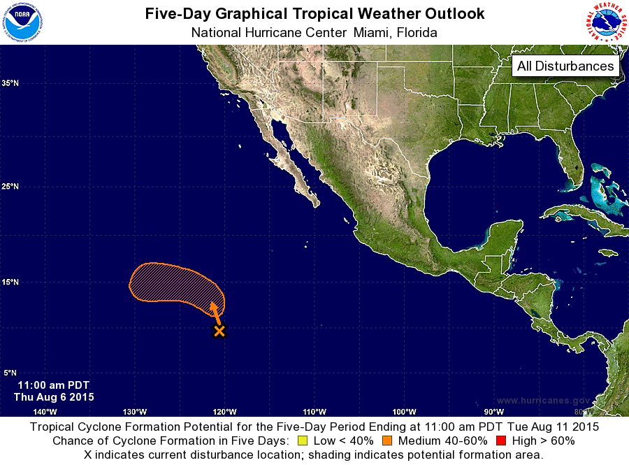
ZCZC MIATWOEP ALL
TTAA00 KNHC DDHHMM

TROPICAL WEATHER OUTLOOK
NWS NATIONAL HURRICANE CENTER MIAMI FL
1100 AM PDT THU AUG 6 2015

For the eastern North Pacific...east of 140 degrees west longitude:

The National Hurricane Center is issuing advisories on recently
upgraded Tropical Storm Hilda, located more than 1500 miles
west-southwest of the southern tip of the Baja California peninsula.

1. Disorganized showers and thunderstorms located more than 1000 miles
southwest of the southern tip of the Baja California peninsula are
associated with a broad area of low pressure. Environmental
conditions are forecast to be conducive for gradual development, and
this system could become a tropical depression by early next week
while it moves generally northwestward at around 10 mph.
* Formation chance through 48 hours...low...near 0 percent
* Formation chance through 5 days...medium...50 percent

Public Advisories on Tropical Storm Hilda are issued under WMO
header WTPZ35 KNHC and under AWIPS header MIATCPEP5.
Forecast/Advisories on Tropical Storm Hilda are issued under
WMO header WTPZ25 KNHC and under AWIPS header MIATCMEP5.

Forecaster Kimberlain
List of Atlantic Outlooks (May 2023 - present)
List of East Pacific Outlooks (May 2023 - present)
List of Central Pacific Outlooks (May 2023 - present)
List of Atlantic Outlooks (July 2014 - April 2023)
List of East Pacific Outlooks (July 2014 - April 2023)
List of Central Pacific Outlooks (June 2019 - April 2023)
List of Atlantic Outlooks (June 2009 - June 2014)
List of East Pacific Outlooks (June 2009 - June 2014)