


NHC Graphical Outlook Archive
|
« Earliest Available ‹ Earlier Later › Latest Available » |
GIS Shapefiles |
| Eastern North Pacific | Atlantic |
|
Tropical Weather Outlook Text
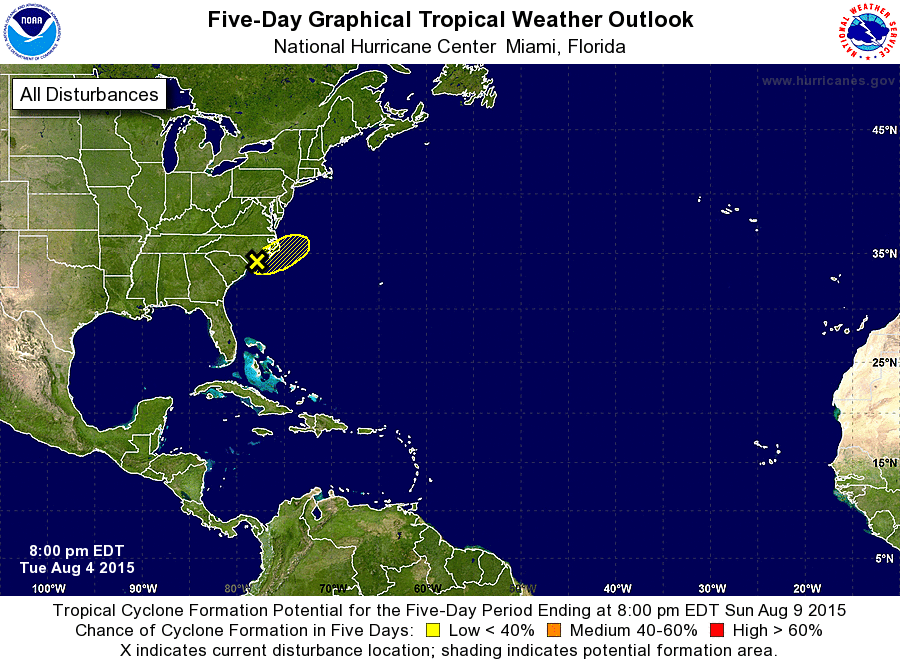
ZCZC MIATWOAT ALL
TTAA00 KNHC DDHHMM

TROPICAL WEATHER OUTLOOK
NWS NATIONAL HURRICANE CENTER MIAMI FL
800 PM EDT TUE AUG 4 2015

For the North Atlantic...Caribbean Sea and the Gulf of Mexico:

1. Surface data indicate that the area of low pressure located over
southeastern North Carolina has become less defined during the past
several hours.  The associated thunderstorm activity also remains
poorly organized, and the potential for this system to become a
tropical cyclone is decreasing.  Regardless of development, this
system is expected to continue to produce gale-force winds over
portions of the western Atlantic tonight before merging with a
frontal system tomorrow.  Additional information on this system
can be found in High Seas Forecasts issued by the National Weather
Service.
* Formation chance through 48 hours...low...10 percent
* Formation chance through 5 days...low...10 percent

High Seas Forecasts issued by the National Weather Service can be
found under AWIPS header NFDHSFAT1 and WMO header FZNT01 KWBC.

Forecaster Brown
List of Atlantic Outlooks (May 2023 - present)
List of East Pacific Outlooks (May 2023 - present)
List of Central Pacific Outlooks (May 2023 - present)
List of Atlantic Outlooks (July 2014 - April 2023)
List of East Pacific Outlooks (July 2014 - April 2023)
List of Central Pacific Outlooks (June 2019 - April 2023)
List of Atlantic Outlooks (June 2009 - June 2014)
List of East Pacific Outlooks (June 2009 - June 2014)