


NHC Graphical Outlook Archive
|
« Earliest Available ‹ Earlier Later › Latest Available » |
GIS Shapefiles |
| Eastern North Pacific | Atlantic |
|
Tropical Weather Outlook Text
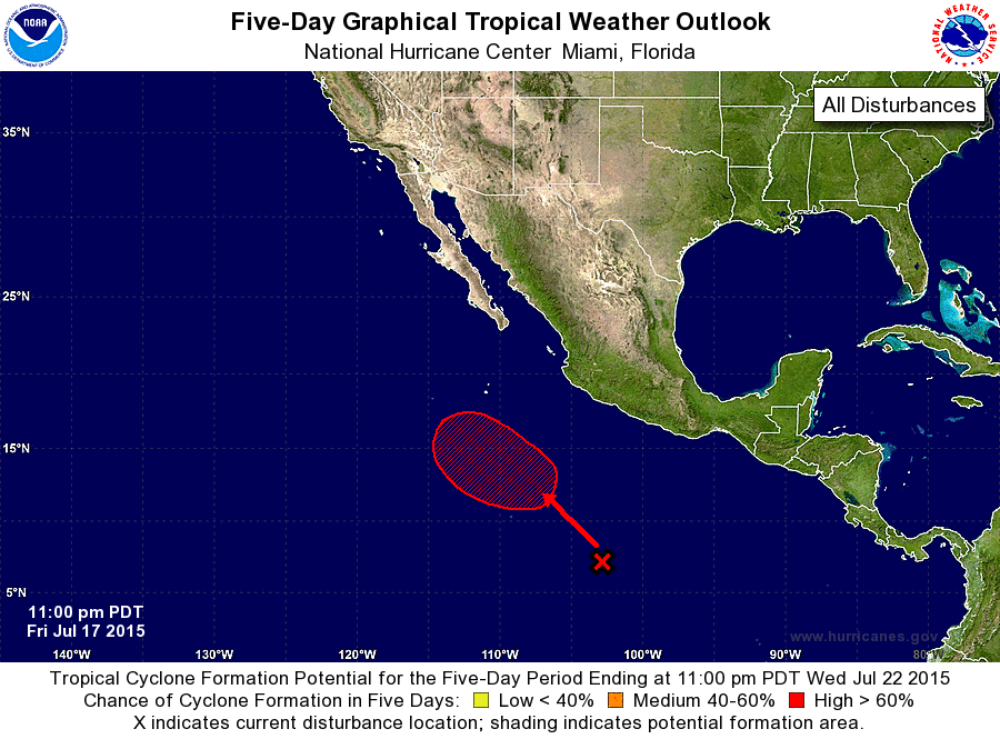
ZCZC MIATWOEP ALL
TTAA00 KNHC DDHHMM

TROPICAL WEATHER OUTLOOK
NWS NATIONAL HURRICANE CENTER MIAMI FL
1100 PM PDT FRI JUL 17 2015

For the eastern North Pacific...east of 140 degrees west longitude:

The National Hurricane Center is issuing advisories on Tropical
Storm Dolores, located a few hundred miles southwest of Cabo San
Lazaro, Mexico, and has issued the the last advisory on Post-
Tropical Cyclone Enrique, located well west of the southern tip of
the Baja California peninsula.

1. A weak area of low pressure located about 700 miles south-southwest
of Acapulco, Mexico, continues to produce a large area of
disorganized shower and thunderstorm activity.  Environmental
conditions are expected to be conducive for gradual development,
and a tropical depression is likely to form early next week while
the low moves slowly west-northwestward or northwestward well
offshore of the coast of Mexico.
* Formation chance through 48 hours...low...near 0 percent
* Formation chance through 5 days...high...70 percent

Forecaster Kimberlain
List of Atlantic Outlooks (May 2023 - present)
List of East Pacific Outlooks (May 2023 - present)
List of Central Pacific Outlooks (May 2023 - present)
List of Atlantic Outlooks (July 2014 - April 2023)
List of East Pacific Outlooks (July 2014 - April 2023)
List of Central Pacific Outlooks (June 2019 - April 2023)
List of Atlantic Outlooks (June 2009 - June 2014)
List of East Pacific Outlooks (June 2009 - June 2014)