


NHC Graphical Outlook Archive
|
« Earliest Available ‹ Earlier Later › Latest Available » |
GIS Shapefiles |
| Eastern North Pacific | Atlantic |
|
Tropical Weather Outlook Text
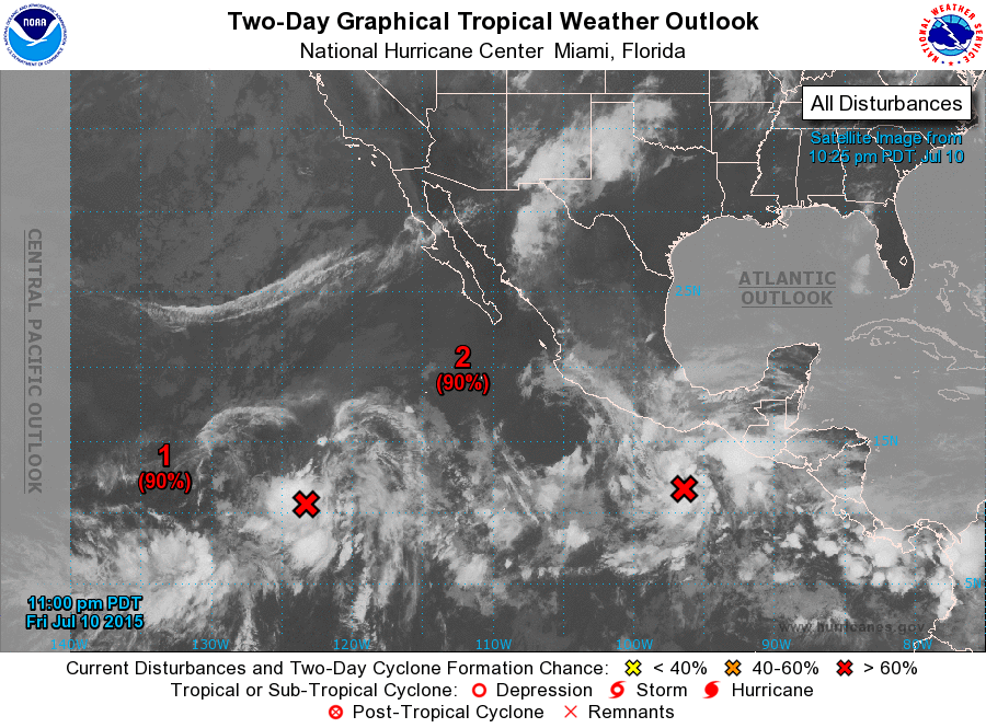
ZCZC MIATWOEP ALL
TTAA00 KNHC DDHHMM

TROPICAL WEATHER OUTLOOK
NWS NATIONAL HURRICANE CENTER MIAMI FL
1100 PM PDT FRI JUL 10 2015

For the eastern North Pacific...east of 140 degrees west longitude:

1. A well-defined area of low pressure located about 1200 miles
southwest of the southern tip of Baja California Sur is moving
north-northwestward at about 10 mph.  Shower and thunderstorm
activity is showing signs of organization, and conditions are
expected to be conducive for development of a tropical depression
during the next day or so.
* Formation chance through 48 hours...high...90 percent
* Formation chance through 5 days...high...90 percent

2. Showers and thunderstorms associated with a well-defined low
pressure system located about 400 miles southeast of Acapulco,
Mexico, are showing signs of organization. Environmental conditions
are conducive for continued development, and this system will likely
become a tropical depression during the next day or so while it
moves northwestward to west-northwestward.  Interests along the
southern and southwestern coasts of Mexico should monitor the
progress of this disturbance.
* Formation chance through 48 hours...high...90 percent
* Formation chance through 5 days...high...90 percent

Forecaster Stewart
List of Atlantic Outlooks (May 2023 - present)
List of East Pacific Outlooks (May 2023 - present)
List of Central Pacific Outlooks (May 2023 - present)
List of Atlantic Outlooks (July 2014 - April 2023)
List of East Pacific Outlooks (July 2014 - April 2023)
List of Central Pacific Outlooks (June 2019 - April 2023)
List of Atlantic Outlooks (June 2009 - June 2014)
List of East Pacific Outlooks (June 2009 - June 2014)