


NHC Graphical Outlook Archive
|
« Earliest Available ‹ Earlier Later › Latest Available » |
GIS Shapefiles |
| Eastern North Pacific | Atlantic |
|
Tropical Weather Outlook Text
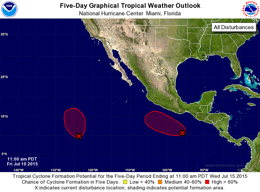
ZCZC MIATWOEP ALL
TTAA00 KNHC DDHHMM

TROPICAL WEATHER OUTLOOK
NWS NATIONAL HURRICANE CENTER MIAMI FL
1100 AM PDT FRI JUL 10 2015

For the eastern North Pacific...east of 140 degrees west longitude:

1. An area of low pressure located about 1300 miles southwest of the
southern tip of Baja California Sur has become better defined
since yesterday.  Further development is expected, and a tropical
depression will likely form over the weekend while the low moves
generally northwestward.
* Formation chance through 48 hours...high...80 percent
* Formation chance through 5 days...high...90 percent

2. Showers and thunderstorms associated with a low pressure about 500
miles south-southeast of Acapulco have become much more concentrated
and better organized during the last 24 hours. Environmental
conditions are expected to be conducive for continued development,
and this system will likely become a tropical depression over the
weekend while it moves generally west- northwestward to
northwestward.
* Formation chance through 48 hours...high...70 percent
* Formation chance through 5 days...high...90 percent

Forecaster Kimberlain
List of Atlantic Outlooks (May 2023 - present)
List of East Pacific Outlooks (May 2023 - present)
List of Central Pacific Outlooks (May 2023 - present)
List of Atlantic Outlooks (July 2014 - April 2023)
List of East Pacific Outlooks (July 2014 - April 2023)
List of Central Pacific Outlooks (June 2019 - April 2023)
List of Atlantic Outlooks (June 2009 - June 2014)
List of East Pacific Outlooks (June 2009 - June 2014)