


NHC Graphical Outlook Archive
|
« Earliest Available ‹ Earlier Later › Latest Available » |
GIS Shapefiles |
| Eastern North Pacific | Atlantic |
|
Tropical Weather Outlook Text
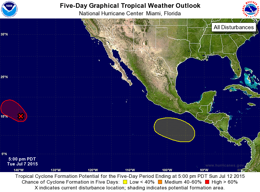
ZCZC MIATWOEP ALL
TTAA00 KNHC DDHHMM

TROPICAL WEATHER OUTLOOK
NWS NATIONAL HURRICANE CENTER MIAMI FL
500 PM PDT TUE JUL 7 2015

For the eastern North Pacific...east of 140 degrees west longitude:

1. Showers and thunderstorms associated with a large area of low
pressure located about 1075 miles east-southeast of the Big Island
of Hawaii continue to show signs of organization. Environmental
conditions are expected to be conducive for further development, and
a tropical cyclone will likely form later tonight while the system
moves west-northwestward at 15 to 20 mph. The low is forecast to
cross 140W longitude and move into the central Pacific basin later
tonight.
* Formation chance through 48 hours...high...90 percent
* Formation chance through 5 days...high...90 percent

2. An area of low pressure is expected to form several hundred miles
south of the coast of southern Mexico later this week. Some
development of this system is possible by this weekend while the
low moves west-northwestward.
* Formation chance through 48 hours...low...near 0 percent
* Formation chance through 5 days...low...30 percent

Forecaster Stewart
List of Atlantic Outlooks (May 2023 - present)
List of East Pacific Outlooks (May 2023 - present)
List of Central Pacific Outlooks (May 2023 - present)
List of Atlantic Outlooks (July 2014 - April 2023)
List of East Pacific Outlooks (July 2014 - April 2023)
List of Central Pacific Outlooks (June 2019 - April 2023)
List of Atlantic Outlooks (June 2009 - June 2014)
List of East Pacific Outlooks (June 2009 - June 2014)