


NHC Graphical Outlook Archive
|
« Earliest Available ‹ Earlier Later › Latest Available » |
GIS Shapefiles |
| Eastern North Pacific | Atlantic |
|
Tropical Weather Outlook Text
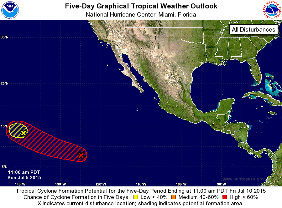
ZCZC MIATWOEP ALL
TTAA00 KNHC DDHHMM

TROPICAL WEATHER OUTLOOK
NWS NATIONAL HURRICANE CENTER MIAMI FL
1100 AM PDT SUN JUL 5 2015

For the eastern North Pacific...east of 140 degrees west longitude:

1. A low pressure system about 1100 miles east-southeast of the
Hawaiian Islands continues to produce disorganized showers and
thunderstorms.  Development of this disturbance is not expected
since upper-level winds are forecast to become unfavorable in a day
or so. The low is forecast to drift westward or west-northwestward
over the next several days.
* Formation chance through 48 hours...low...10 percent
* Formation chance through 5 days...low...10 percent

2. A large area of showers and thunderstorms centered about 1550 miles
southwest of the southern tip of Baja California Sur is associated
with an elongated area of low pressure.  While the low is not
currently well defined, environmental conditions appear to be
conducive for gradual development.  A tropical depression is
still expected to form by mid-week while the system moves west-
northwestward about 15 mph.
* Formation chance through 48 hours...medium...50 percent
* Formation chance through 5 days...high...90 percent

Forecaster Blake
List of Atlantic Outlooks (May 2023 - present)
List of East Pacific Outlooks (May 2023 - present)
List of Central Pacific Outlooks (May 2023 - present)
List of Atlantic Outlooks (July 2014 - April 2023)
List of East Pacific Outlooks (July 2014 - April 2023)
List of Central Pacific Outlooks (June 2019 - April 2023)
List of Atlantic Outlooks (June 2009 - June 2014)
List of East Pacific Outlooks (June 2009 - June 2014)