


NHC Graphical Outlook Archive
|
« Earliest Available ‹ Earlier Later › Latest Available » |
GIS Shapefiles |
| Eastern Pacific | Atlantic |
|
Tropical Weather Outlook Text
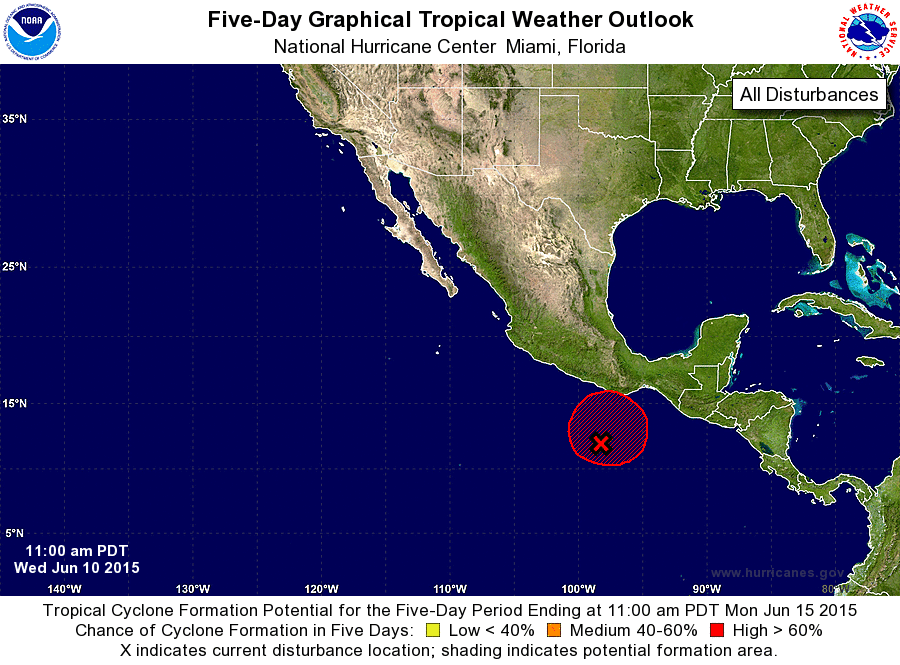
ZCZC MIATWOEP ALL
TTAA00 KNHC DDHHMM

TROPICAL WEATHER OUTLOOK
NWS NATIONAL HURRICANE CENTER MIAMI FL
1100 AM PDT WED JUN 10 2015

For the eastern North Pacific...east of 140 degrees west longitude:

1. Showers and thunderstorms associated with a low pressure area a
few hundred miles southwest of the Gulf of Tehuantepec continue
to show signs of organization.  Environmental conditions are
conducive for development, and a tropical depression is likely to
form later today or tonight while the system moves slowly
northwestward or northward.  Interests in southern Mexico should
monitor the progress of this system.  A tropical storm or hurricane
watch could be required for a portion of the coast of Mexico near
the Gulf of Tehuantepec later today.
* Formation chance through 48 hours...high...90 percent
* Formation chance through 5 days...high...90 percent

Forecaster Pasch/Landsea
List of Atlantic Outlooks (May 2023 - present)
List of East Pacific Outlooks (May 2023 - present)
List of Central Pacific Outlooks (May 2023 - present)
List of Atlantic Outlooks (July 2014 - April 2023)
List of East Pacific Outlooks (July 2014 - April 2023)
List of Central Pacific Outlooks (June 2019 - April 2023)
List of Atlantic Outlooks (June 2009 - June 2014)
List of East Pacific Outlooks (June 2009 - June 2014)