


NHC Graphical Outlook Archive
|
« Earliest Available ‹ Earlier Later › Latest Available » |
GIS Shapefiles |
| Eastern Pacific | Atlantic |
|
|
(mouse over shaded areas for details; click on shaded areas or disturbance numbers to switch views) |
Tropical Weather Outlook Text
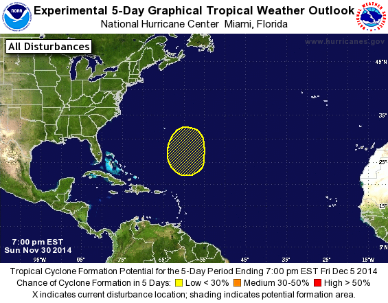
TROPICAL WEATHER OUTLOOK
NWS NATIONAL HURRICANE CENTER MIAMI FL
700 PM EST SUN NOV 30 2014

For the North Atlantic...Caribbean Sea and the Gulf of Mexico:

1. A non-tropical area of low pressure could develop a few hundred
miles northeast of the northern Leeward Islands by Thursday or
Friday. This system could gradually acquire some subtropical
characteristics while it moves slowly northward to north-
northeastward. Additional outlooks on this system will only be
issued if the development potential increases significantly.
* Formation chance through 48 hours...low...near 0 percent.
* Formation chance through 5 days...low...10 percent.

This is the last regularly scheduled Tropical Weather Outlook of the
2014 Atlantic hurricane season. Routine issuance of the Tropical
Weather Outlook will resume on June 1, 2015. During the off-season,
Special Tropical Weather Outlooks will be issued as conditions
warrant.

Forecaster Brennan
List of Atlantic Outlooks (May 2023 - present)
List of East Pacific Outlooks (May 2023 - present)
List of Central Pacific Outlooks (May 2023 - present)
List of Atlantic Outlooks (July 2014 - April 2023)
List of East Pacific Outlooks (July 2014 - April 2023)
List of Central Pacific Outlooks (June 2019 - April 2023)
List of Atlantic Outlooks (June 2009 - June 2014)
List of East Pacific Outlooks (June 2009 - June 2014)