


NHC Graphical Outlook Archive
|
« Earliest Available ‹ Earlier Later › Latest Available » |
| Eastern Pacific | Atlantic |
|
|
(mouse over shaded areas for details; click on shaded areas or disturbance numbers to switch views) |
Tropical Weather Outlook Text
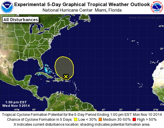
TROPICAL WEATHER OUTLOOK
NWS NATIONAL HURRICANE CENTER MIAMI FL
100 PM EST WED NOV 5 2014

For the North Atlantic...Caribbean Sea and the Gulf of Mexico:

1. A weak area of low pressure appears to be forming a couple of
hundred miles north of Puerto Rico.  This system is interacting with
an upper-level low and is currently producing a large area of
disorganized cloudiness and showers.  There is some potential for
this low to briefly acquire subtropical characteristics during
the next day or so while it moves northwestward.  After that time,
development is not expected as the disturbance moves
north-northeastward and merges with a frontal zone.  Regardless of
formation, locally heavy rainfall and possible flooding should
continue across Puerto Rico and the Dominican Republic through
tonight.  For additional information on the heavy rainfall threat,
please consult products issued by your national meteorological
service.
* Formation chance through 48 hours...low...20 percent.
* Formation chance through 5 days...low...20 percent.

Forecaster Cangialosi/Beven
List of Atlantic Outlooks (May 2023 - present)
List of East Pacific Outlooks (May 2023 - present)
List of Central Pacific Outlooks (May 2023 - present)
List of Atlantic Outlooks (July 2014 - April 2023)
List of East Pacific Outlooks (July 2014 - April 2023)
List of Central Pacific Outlooks (June 2019 - April 2023)
List of Atlantic Outlooks (June 2009 - June 2014)
List of East Pacific Outlooks (June 2009 - June 2014)