


NHC Graphical Outlook Archive
|
« Earliest Available ‹ Earlier Later › Latest Available » |
| Eastern Pacific | Atlantic |
|
|
(mouse over shaded areas for details; click on shaded areas or disturbance numbers to switch views) |
Tropical Weather Outlook Text
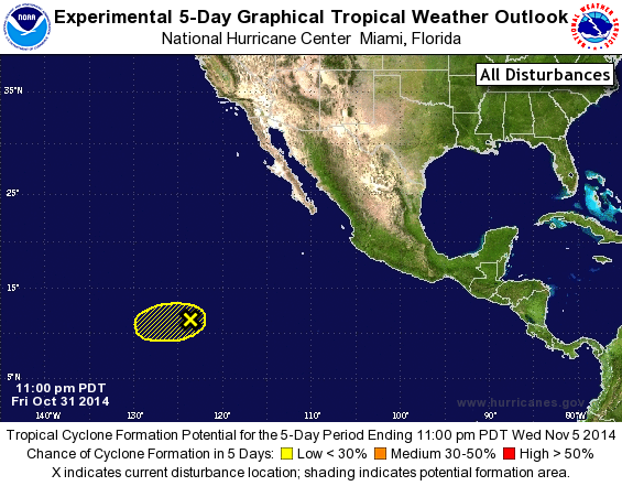
TROPICAL WEATHER OUTLOOK
NWS NATIONAL HURRICANE CENTER MIAMI FL
1100 PM PDT FRI OCT 31 2014

For the eastern North Pacific...east of 140 degrees west longitude:

The National Hurricane Center is issuing advisories on Tropical
Storm Vance, located several hundred miles south-southwest of
Acapulco, Mexico.

1. Showers and thunderstorms associated with an area of low pressure
located about 1150 miles southwest of the southern tip of the Baja
California peninsula have weakened during the past few hours.
Although upper-level winds are forecast to be generally favorable
for the next day or two, dry air in the vicinity of the system
should limit significant development while it moves toward the west
or west-southwest at 5 to 10 mph during the next few days.
* Formation chance through 48 hours...low..10 percent.
* Formation chance through 5 days...low...20 percent.

Forecaster Berg
List of Atlantic Outlooks (May 2023 - present)
List of East Pacific Outlooks (May 2023 - present)
List of Central Pacific Outlooks (May 2023 - present)
List of Atlantic Outlooks (July 2014 - April 2023)
List of East Pacific Outlooks (July 2014 - April 2023)
List of Central Pacific Outlooks (June 2019 - April 2023)
List of Atlantic Outlooks (June 2009 - June 2014)
List of East Pacific Outlooks (June 2009 - June 2014)