


NHC Graphical Outlook Archive
|
« Earliest Available ‹ Earlier Later › Latest Available » |
| Eastern Pacific | Atlantic |
|
|
(mouse over shaded areas for details; click on shaded areas or disturbance numbers to switch views) |
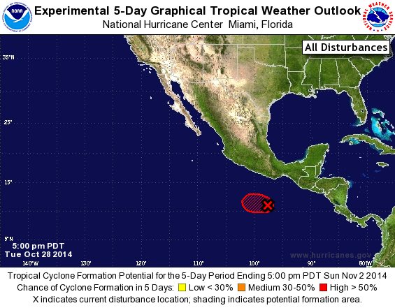
Tropical Weather Outlook Text
TROPICAL WEATHER OUTLOOK
NWS NATIONAL HURRICANE CENTER MIAMI FL
500 PM PDT TUE OCT 28 2014

For the eastern North Pacific...east of 140 degrees west longitude:

1. Showers and thunderstorms associated with the area of low pressure
located several hundred miles south-southwest of Puerto Angel,
Mexico, are not particularly well organized, and it is not yet clear
that the low has developed a well-defined center of circulation.
However, environmental conditions are conducive for further
development, and a tropical depression is still expected to form
tonight or on Wednesday while the low moves west-northwestward at
about 5 mph.
* Formation chance through 48 hours...high...near 100 percent.
* Formation chance through 5 days...high...near 100 percent.

Forecaster Berg
List of Atlantic Outlooks (May 2023 - present)
List of East Pacific Outlooks (May 2023 - present)
List of Central Pacific Outlooks (May 2023 - present)
List of Atlantic Outlooks (July 2014 - April 2023)
List of East Pacific Outlooks (July 2014 - April 2023)
List of Central Pacific Outlooks (June 2019 - April 2023)
List of Atlantic Outlooks (June 2009 - June 2014)
List of East Pacific Outlooks (June 2009 - June 2014)