


NHC Graphical Outlook Archive
|
« Earliest Available ‹ Earlier Later › Latest Available » |
| Eastern Pacific | Atlantic |
|
|
(mouse over shaded areas for details; click on shaded areas or disturbance numbers to switch views) |
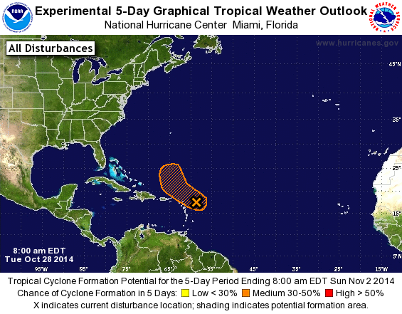
Tropical Weather Outlook Text
TROPICAL WEATHER OUTLOOK
NWS NATIONAL HURRICANE CENTER MIAMI FL
800 AM EDT TUE OCT 28 2014

For the North Atlantic...Caribbean Sea and the Gulf of Mexico:

1. A tropical wave interacting with an upper-level trough continues to
produce a large area of cloudiness and disorganized thunderstorms
from the Lesser Antilles eastward over the Atlantic Ocean for
several hundred miles. Since upper-level winds are expected to be
marginally conducive, some gradual development of this disturbance
is possible while it moves northwestward to west-northwestward at
10 to 15 mph during the next few days.  By the weekend, however,
conditions are expected to become unfavorable for tropical cyclone
formation. Regardless of development, this system will produce brief
periods of gusty winds and locally heavy rainfall across portions of
the Lesser Antilles through today.
* Formation chance through 48 hours...low...20 percent.
* Formation chance through 5 days...medium...30 percent.

Forecaster Stewart
List of Atlantic Outlooks (May 2023 - present)
List of East Pacific Outlooks (May 2023 - present)
List of Central Pacific Outlooks (May 2023 - present)
List of Atlantic Outlooks (July 2014 - April 2023)
List of East Pacific Outlooks (July 2014 - April 2023)
List of Central Pacific Outlooks (June 2019 - April 2023)
List of Atlantic Outlooks (June 2009 - June 2014)
List of East Pacific Outlooks (June 2009 - June 2014)