


NHC Graphical Outlook Archive
|
« Earliest Available ‹ Earlier Later › Latest Available » |
| Eastern Pacific | Atlantic |
|
|
(mouse over shaded areas for details; click on shaded areas or disturbance numbers to switch views) |
Tropical Weather Outlook Text
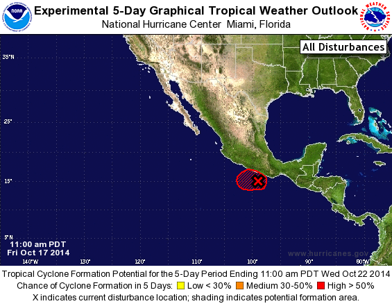
TROPICAL WEATHER OUTLOOK
NWS NATIONAL HURRICANE CENTER MIAMI FL
1100 AM PDT FRI OCT 17 2014

For the eastern North Pacific...east of 140 degrees west longitude:

1. Numerous showers and thunderstorms continue in association with an
area of low pressure centered around 100 miles south of Acapulco,
Mexico.  Environmental conditions are conducive for further
development and a tropical depression may form later today or on
Saturday, as the system moves slowly north or northwestward. If a
tropical cyclone does develop, tropical storm watches or warnings
may be necessary for a portion of the southern coast of Mexico.
Interests in this area should closely monitor the progress of the
system. Heavy rainfall and localized flooding associated with this
system could produce flash flooding and mudslides in portions of
southern Mexico, especially near areas of elevated terrain during
the next couple of days.
* Formation chance through 48 hours..high...80 percent.
* Formation chance through 5 days...high...80 percent.

Forecaster Landsea
List of Atlantic Outlooks (May 2023 - present)
List of East Pacific Outlooks (May 2023 - present)
List of Central Pacific Outlooks (May 2023 - present)
List of Atlantic Outlooks (July 2014 - April 2023)
List of East Pacific Outlooks (July 2014 - April 2023)
List of Central Pacific Outlooks (June 2019 - April 2023)
List of Atlantic Outlooks (June 2009 - June 2014)
List of East Pacific Outlooks (June 2009 - June 2014)