


NHC Graphical Outlook Archive
|
« Earliest Available ‹ Earlier Later › Latest Available » |
| Eastern Pacific | Atlantic |
|
|
(mouse over weather symbols for details; click on weather symbols or disturbance numbers to switch views) |
Tropical Weather Outlook Text
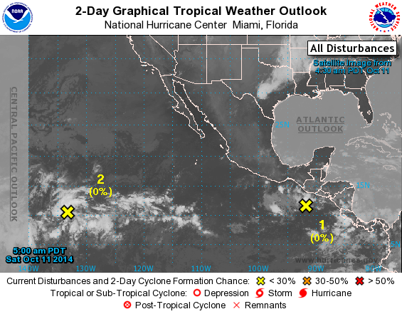
TROPICAL WEATHER OUTLOOK
NWS NATIONAL HURRICANE CENTER MIAMI FL
500 AM PDT SAT OCT 11 2014

For the eastern North Pacific...east of 140 degrees west longitude:

1. Disorganized but limited cloudiness and showers, associated with an
elongated trough of low pressure, extend from near the coast of
Nicaragua to a few hundred miles south-southwest of the Gulf of
Tehuantepec. While development of this system is not likely during
the next couple of days, environmental conditions are expected to
become conducive for some gradual development of this disturbance by
the middle of next week.
* Formation chance through 48 hours...low...near 0 percent.
* Formation chance through 5 days...low...20 percent.

2. Cloudiness and thunderstorms located about 1500 miles east-
southeast of the Hawaiian Islands are associated with a surface
trough. Environmental conditions are conducive for slow development
of this system during the next several days while it moves westward
or west-northwestward at around 15 mph.
* Formation chance through 48 hours...low...near 0 percent.
* Formation chance through 5 days...low...20 percent.

Forecaster Kimberlain
List of Atlantic Outlooks (May 2023 - present)
List of East Pacific Outlooks (May 2023 - present)
List of Central Pacific Outlooks (May 2023 - present)
List of Atlantic Outlooks (July 2014 - April 2023)
List of East Pacific Outlooks (July 2014 - April 2023)
List of Central Pacific Outlooks (June 2019 - April 2023)
List of Atlantic Outlooks (June 2009 - June 2014)
List of East Pacific Outlooks (June 2009 - June 2014)