


NHC Graphical Outlook Archive
|
« Earliest Available ‹ Earlier Later › Latest Available » |
| Eastern Pacific | Atlantic |
|
|
(mouse over shaded areas for details; click on shaded areas or disturbance numbers to switch views) |
Tropical Weather Outlook Text
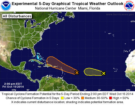
TROPICAL WEATHER OUTLOOK...Corrected
NWS NATIONAL HURRICANE CENTER MIAMI FL
200 PM EDT FRI OCT 10 2014

Corrected to change category of first system from low to medium

For the North Atlantic...Caribbean Sea and the Gulf of Mexico:

The National Hurricane Center is issuing advisories on newly
formed Subtropical Depression Seven located several hundred miles
south of Bermuda.

1. Shower and thunderstorm activity associated with a tropical wave
located about 700 miles east of the Lesser Antilles has changed
little in organization today. However, environmental conditions are
conducive for gradual development of this system during the next
several days while it moves westward or west-northwestward at about
10 mph.
* Formation chance through 48 hours...low...10 percent.
* Formation chance through 5 days...medium...30 percent.

2. A concentrated area of showers and thunderstorms located several
hundred miles west of the Cape Verde Islands is associated with
a westward-moving tropical wave.  Upper-level winds are not
favorable, and significant development of this system is unlikely.
* Formation chance through 48 hours...low...10 percent.
* Formation chance through 5 days...low...10 percent.

Forecaster Kimberlain
List of Atlantic Outlooks (May 2023 - present)
List of East Pacific Outlooks (May 2023 - present)
List of Central Pacific Outlooks (May 2023 - present)
List of Atlantic Outlooks (July 2014 - April 2023)
List of East Pacific Outlooks (July 2014 - April 2023)
List of Central Pacific Outlooks (June 2019 - April 2023)
List of Atlantic Outlooks (June 2009 - June 2014)
List of East Pacific Outlooks (June 2009 - June 2014)