


NHC Graphical Outlook Archive
|
« Earliest Available ‹ Earlier Later › Latest Available » |
| Eastern Pacific | Atlantic |
|
|
(mouse over shaded areas for details; click on shaded areas or disturbance numbers to switch views) |
Tropical Weather Outlook Text
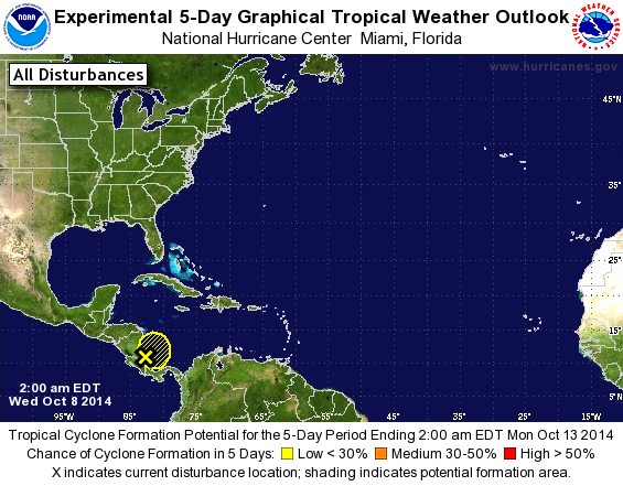
TROPICAL WEATHER OUTLOOK
NWS NATIONAL HURRICANE CENTER MIAMI FL
200 AM EDT WED OCT 8 2014

For the North Atlantic...Caribbean Sea and the Gulf of Mexico:

1. A broad area of low pressure located over the extreme southwestern
Caribbean Sea is producing disorganized cloudiness and showers.
The low is expected to drift westward near or over Central America
during the next couple of days, and development is likely to be
limited by its proximity to land.  Regardless of development, heavy
rains are possible over portions of Central America during the next
few days.
*Formation change through 48 hours...low...10 percent.
*Formation chance through 5 days...low...10 percent.

Forecaster Brown
List of Atlantic Outlooks (May 2023 - present)
List of East Pacific Outlooks (May 2023 - present)
List of Central Pacific Outlooks (May 2023 - present)
List of Atlantic Outlooks (July 2014 - April 2023)
List of East Pacific Outlooks (July 2014 - April 2023)
List of Central Pacific Outlooks (June 2019 - April 2023)
List of Atlantic Outlooks (June 2009 - June 2014)
List of East Pacific Outlooks (June 2009 - June 2014)