


NHC Graphical Outlook Archive
|
« Earliest Available ‹ Earlier Later › Latest Available » |
| Eastern Pacific | Atlantic |
|
|
(mouse over shaded areas for details; click on shaded areas or disturbance numbers to switch views) |
Tropical Weather Outlook Text
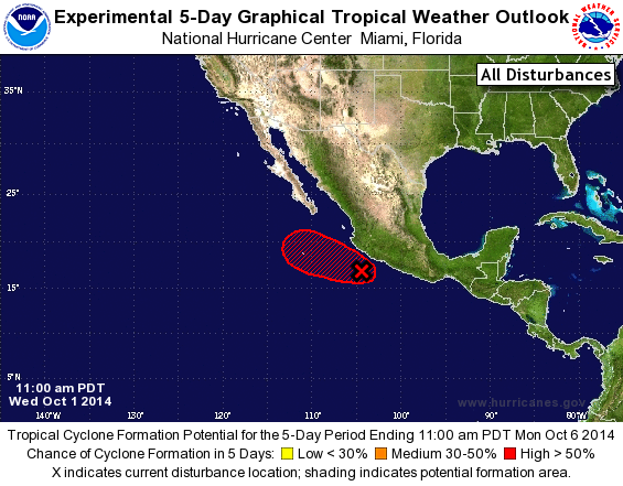
TROPICAL WEATHER OUTLOOK
NWS NATIONAL HURRICANE CENTER MIAMI FL
1100 AM PDT WED OCT 1 2014

For the eastern North Pacific...east of 140 degrees west longitude:

1. Satellite imagery indicates that shower and thunderstorm activity
associated with an area of low pressure located about 150 miles
south of Manzanillo, Mexico, has become better organized during the
past few hours. In addition, satellite data indicate that the
low-level circulation has become better defined this morning.
A tropical depression is expected to form later today or Thursday
while the system moves toward the west-northwest at around 10 mph.
Regardless of tropical cyclone formation, this disturbance will
likely produce locally heavy rains over coastal portions of southern
Mexico that could cause flash flooding and mud slides during the
next day or two.
* Formation chance through 48 hours...high...90 percent.
* Formation chance through 5 days...high...90 percent.

Forecaster Brennan
List of Atlantic Outlooks (May 2023 - present)
List of East Pacific Outlooks (May 2023 - present)
List of Central Pacific Outlooks (May 2023 - present)
List of Atlantic Outlooks (July 2014 - April 2023)
List of East Pacific Outlooks (July 2014 - April 2023)
List of Central Pacific Outlooks (June 2019 - April 2023)
List of Atlantic Outlooks (June 2009 - June 2014)
List of East Pacific Outlooks (June 2009 - June 2014)