


NHC Graphical Outlook Archive
|
« Earliest Available ‹ Earlier Later › Latest Available » |
| Eastern Pacific | Atlantic |
|
|
(mouse over shaded areas for details; click on shaded areas or disturbance numbers to switch views) |
Tropical Weather Outlook Text
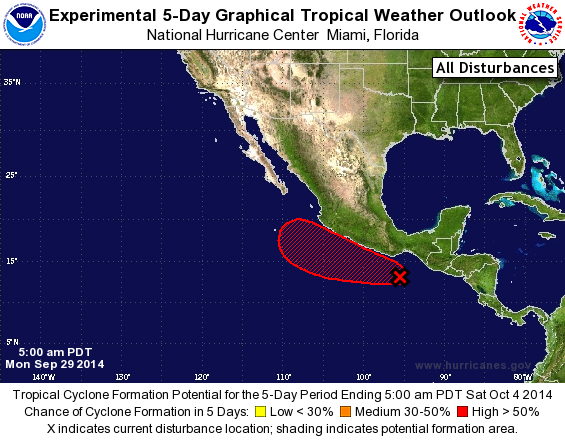
TROPICAL WEATHER OUTLOOK
NWS NATIONAL HURRICANE CENTER MIAMI FL
500 AM PDT MON SEP 29 2014

For the eastern North Pacific...east of 140 degrees west longitude:

The National Hurricane Center is issuing advisories on Hurricane
Rachel, located several hundred miles west of the southern tip of
the Baja California peninsula.

1. A large area of disorganized showers and thunderstorms extending
from near the coast of southern Mexico southeastward for several
hundred miles is associated with a trough of low pressure.
Environmental conditions are expected to gradually become more
conducive for development during the next several days, and a
tropical depression could form later this week while the system
drifts west-northwestward or northwestward.  Regardless of
development, this system could produce locally heavy rains over
portions of southern Mexico that could cause flash floods and mud
slides.
* Formation chance through 48 hours...low...20 percent.
* Formation chance through 5 days...high...70 percent.

Forecaster Kimberlain/Lewitsky
List of Atlantic Outlooks (May 2023 - present)
List of East Pacific Outlooks (May 2023 - present)
List of Central Pacific Outlooks (May 2023 - present)
List of Atlantic Outlooks (July 2014 - April 2023)
List of East Pacific Outlooks (July 2014 - April 2023)
List of Central Pacific Outlooks (June 2019 - April 2023)
List of Atlantic Outlooks (June 2009 - June 2014)
List of East Pacific Outlooks (June 2009 - June 2014)