


NHC Graphical Outlook Archive
|
« Earliest Available ‹ Earlier Later › Latest Available » |
| Eastern Pacific | Atlantic |
|
|
(mouse over shaded areas for details; click on shaded areas or disturbance numbers to switch views) |
Tropical Weather Outlook Text
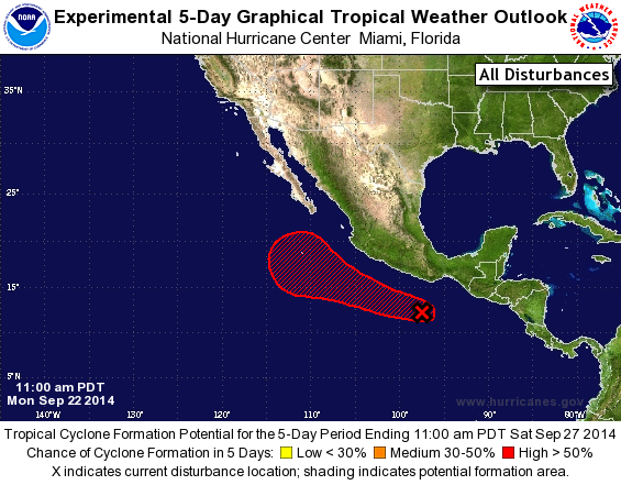
TROPICAL WEATHER OUTLOOK
NWS NATIONAL HURRICANE CENTER MIAMI FL
1100 AM PDT MON SEP 22 2014

For the eastern North Pacific...east of 140 degrees west longitude:

The National Hurricane Center has issued the last advisory on Post-
Tropical Cyclone Polo, located a few hundred miles west of the
southern tip of the Baja California peninsula.

1. Shower and thunderstorm activity associated with a low pressure area
located about 300 hundred miles south-southeast of Acapulco, Mexico,
is showing signs of organization. Environmental conditions are
conducive for development, and a tropical depression is likely to
form during the next day or two while the low moves west-
northwestward at around 10 mph.
* Formation chance through 48 hours...high...70 percent.
* Formation chance through 5 days...high...90 percent.

Forecaster Kimberlain
List of Atlantic Outlooks (May 2023 - present)
List of East Pacific Outlooks (May 2023 - present)
List of Central Pacific Outlooks (May 2023 - present)
List of Atlantic Outlooks (July 2014 - April 2023)
List of East Pacific Outlooks (July 2014 - April 2023)
List of Central Pacific Outlooks (June 2019 - April 2023)
List of Atlantic Outlooks (June 2009 - June 2014)
List of East Pacific Outlooks (June 2009 - June 2014)